IMAGES TAKEN NEAR TO
MAYBOLE, KA19 7QG
Introduction
This page details the photographs taken nearby to KA19 7QG by members of the Geograph project.
The Geograph project started in 2005 with the aim of publishing, organising and preserving representative images for every square kilometre of Great Britain, Ireland and the Isle of Man.

There are currently over 7.5m images from over14,400 individuals and you can help contribute to the project by visiting https://www.geograph.org.uk
Image Map
Images are licensed for reuse under creativecommons.org/licenses/by-sa/2.0
Notes
- Clicking on the map will re-center to the selected point.
- The higher the marker number, the further away the image location is from the centre of the postcode.
Image Listing (12 Images Found)
Images are licensed for reuse under creativecommons.org/licenses/by-sa/2.0
Image
Details
Distance
1
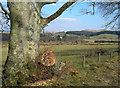
Towards Shawsknowe
Looking towards Shawsknowe Farm from the hill road. Many of the old roadside beech trees have had to be cut back after this year's winter storm damage.
Image: © Mary and Angus Hogg
Taken: 25 Mar 2007
0.03 miles
2
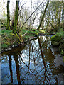
Balsaggart Burn view
Looking upstream at the end of April after a long spell of dry weather.
Image: © Mary and Angus Hogg
Taken: 30 Apr 2020
0.18 miles
3
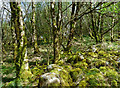
Woodland near Auchalton Meadow
An end-April view of this small wood beside Auchalton Meadow. The overgrown boulders in the foreground mark the edge of an old track that's now impossible to use.
Image: © Mary and Angus Hogg
Taken: 30 Apr 2020
0.20 miles
4
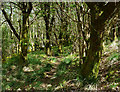
Woodland path near Auchalton Meadow
This path probably is made by animals as it doesn't lead anywhere in a wood that is completely overgrown. Viewed at the end of April before the foliage had opened out.
Image: © Mary and Angus Hogg
Taken: 30 Apr 2020
0.20 miles
5
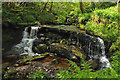
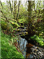
Waterfall on Balsaggart Burn
A lovely waterfall on Balsaggart Burn, hidden away in a deep cleft at the Scottish Wildlife Trust's Auchalton Meadow site. These deep cuts were used by Covenanters on the run from the government forces during Scotland's 17th century religious struggles. Viewed in late May below well-opened foliage.
Image: © Mary and Angus Hogg
Taken: 30 May 2015
0.22 miles
6
Balsaggart Burn
Looking down the burn towards the crossing point at the end of the access track from Auchalton Meadow. The water level was extremely low for the time of year.
Image: © Mary and Angus Hogg
Taken: 30 Apr 2020
0.22 miles
7
Balsaggart Burn In Spring
Balsaggart Burn flowing through a deep cleft at the Scottish Wildlife Trust's Auchalton Meadow site. These deep cuts were used by Covenanters on the run from the government forces during Scotland's 17th century religious struggles. Viewed in late May below well-opened foliage.
Image: © Mary and Angus Hogg
Taken: 30 May 2015
0.23 miles
8
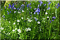
Bluebells and Stitchwort at Auchalton
A lovely spring show of bluebells and stitchwort under the trees at the Scottish Wildlife Trust's Auchalton Meadow site.
Image: © Mary and Angus Hogg
Taken: 30 May 2015
0.23 miles
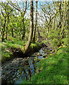
9
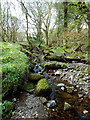
A Pool on Balsaggart Burn
Looking downstream in mid-April before the new season's foliage had opened out. The water level was low after nearly two weeks of dry weather.
Image: © Mary and Angus Hogg
Taken: 22 Apr 2014
0.23 miles
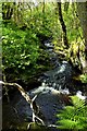
10
Looking Up Balsaggart Burn
Looking upstream in mid-April before the new season's foliage had opened out. The water level was low after nearly two weeks of dry weather. Balsaggart Burn flows through the Scottish Wildlife Trust's reserve at Auchalton Meadow.
Image: © Mary and Angus Hogg
Taken: 22 Apr 2014
0.24 miles