IMAGES TAKEN NEAR TO
Kirkland Street, MAYBOLE, KA19 7HD
Introduction
This page details the photographs taken nearby to Kirkland Street, KA19 7HD by members of the Geograph project.
The Geograph project started in 2005 with the aim of publishing, organising and preserving representative images for every square kilometre of Great Britain, Ireland and the Isle of Man.

There are currently over 7.5m images from over14,400 individuals and you can help contribute to the project by visiting https://www.geograph.org.uk
Image Map
Images are licensed for reuse under creativecommons.org/licenses/by-sa/2.0
Notes
- Clicking on the map will re-center to the selected point.
- The higher the marker number, the further away the image location is from the centre of the postcode.
Image Listing (361 Images Found)
Images are licensed for reuse under creativecommons.org/licenses/by-sa/2.0
Image
Details
Distance
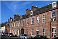
1
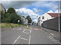
Kirkland Street
Street in the direction of Ayr taken from the junction with St Cuthbert's St.
Image: © Billy McCrorie
Taken: 25 Aug 2011
0.02 miles
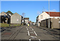
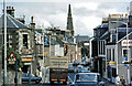
3
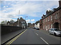
Cassillis Road
Going in the direction of the High Street.
Image: © Billy McCrorie
Taken: 24 Apr 2012
0.04 miles
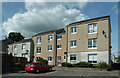
4
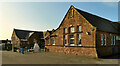
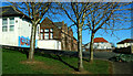
Cairn Primary School entrance
Maybole’s oldest primary school was closed in 2023 when it merged with Gardenrose PS to form the new Culzean Primary School in Maybole Community Campus. See Image Now redundant, this spacious site is expected to be used for housing.
Image: © Mary and Angus Hogg
Taken: 28 May 2023
0.04 miles
7
Bryant's Close, Maybole
Council housing area near Kirkland Street. Being built on a hillside, many parts of Maybole enjoy excellent views.
Image: © Mary and Angus Hogg
Taken: 25 Jul 2018
0.05 miles
8
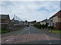
Cairnfield Avenue
Going towards Kirkland Street.
Image: © Billy McCrorie
Taken: 13 Jun 2012
0.06 miles
9
Cairn Primary School
Maybole’s oldest primary school was closed in 2023 when it merged with Gardenrose PS to form the new Culzean Primary School in Maybole Community Campus. See Image Now redundant, this spacious site is expected to be used for housing.
Image: © Mary and Angus Hogg
Taken: 6 Mar 2022
0.06 miles
10
Cassillis Road, Maybole, 1974
This shot shows a busy route centre in Maybole but with vehicles sufficiently small to keep moving. See Image for a 2019 view. The junction shown here is known as McQuiston's Corner, named after the ironmonger's shop which is shown here, open for business, on the left.
Image: © Mary and Angus Hogg
Taken: Unknown
0.06 miles