IMAGES TAKEN NEAR TO
Coral Glen, MAYBOLE, KA19 7EB
Introduction
This page details the photographs taken nearby to Coral Glen, KA19 7EB by members of the Geograph project.
The Geograph project started in 2005 with the aim of publishing, organising and preserving representative images for every square kilometre of Great Britain, Ireland and the Isle of Man.

There are currently over 7.5m images from over14,400 individuals and you can help contribute to the project by visiting https://www.geograph.org.uk
Image Map
Images are licensed for reuse under creativecommons.org/licenses/by-sa/2.0
Notes
- Clicking on the map will re-center to the selected point.
- The higher the marker number, the further away the image location is from the centre of the postcode.
Image Listing (217 Images Found)
Images are licensed for reuse under creativecommons.org/licenses/by-sa/2.0
Image
Details
Distance
9
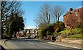
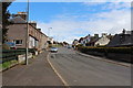
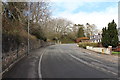
Kirkoswald Road, Maybole
Looking along Kirkoswald Road with its traditional red sandstone buildings. This is the A77 road connecting Glasgow and Stranraer, viewed at a quiet spell for traffic. It's not always so quiet - see Image taken on the same day looking into the town.
Image: © Mary and Angus Hogg
Taken: 8 Apr 2009
0.04 miles