IMAGES TAKEN NEAR TO
Cassillis Road, MAYBOLE, KA19 7BF
Introduction
This page details the photographs taken nearby to Cassillis Road, KA19 7BF by members of the Geograph project.
The Geograph project started in 2005 with the aim of publishing, organising and preserving representative images for every square kilometre of Great Britain, Ireland and the Isle of Man.

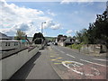
There are currently over 7.5m images from over14,400 individuals and you can help contribute to the project by visiting https://www.geograph.org.uk
Image Map
Images are licensed for reuse under creativecommons.org/licenses/by-sa/2.0
Notes
- Clicking on the map will re-center to the selected point.
- The higher the marker number, the further away the image location is from the centre of the postcode.
Image Listing (263 Images Found)
Images are licensed for reuse under creativecommons.org/licenses/by-sa/2.0
Image
Details
Distance
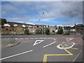
1
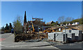
Building Site On Cassillis Road
New flats are being built on the site of Jack's agricultural machinery factory, the site having lain derelict for a long time. Image shows the cleared site. The spire of Maybole Parish Church, also now derelict, is shown in the background.
Image: © Mary and Angus Hogg
Taken: 20 Apr 2016
0.01 miles
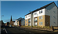
2
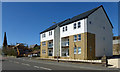
New Flats On Cassillis Road
These new flats have been built on the site of a former agricultural machinery factory. More are under construction on the rest of the site. Part of the original masonry has been used to mark the entrance on the right - see Image
Image: © Mary and Angus Hogg
Taken: 20 Apr 2016
0.01 miles
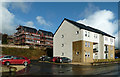
3
Cassillis Road Building Site
This is the second block of flats to be built on the site, next to the old Parish Church. The site was cleared of the former agricultural machinery works to facilitate this development - see Image
Image: © Mary and Angus Hogg
Taken: 20 Apr 2016
0.02 miles
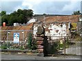
4
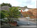
Where Jack's Engineering Works Stood
The first buildings on this site were an early 19th century sawmill and factory, constructed on two levels. Later it became the home of Jack & Son, famous for producing agricultural implements. The factory building was last used by Interpak. The whole site is now being cleared, revealing the outlines of the original buildings.
Image: © Mary and Angus Hogg
Taken: 2 Sep 2009
0.02 miles
5
Kirkland Street
Approaching the junction with Cassillis Road.
Image: © Billy McCrorie
Taken: 24 Apr 2012
0.02 miles
6
Jack's Gait View
Looking along Cassillis Road towards Maybole town centre. The new flats are at Jack's Gait, named after the old factory that produced agricultural machinery. Part of the original masonry has been retained at the entrance on the right - see Image
Image: © Mary and Angus Hogg
Taken: 2 Nov 2017
0.02 miles
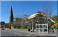
7
More Building At Jack's Gait
With the roadside site completed, work is under way on the higher level block. For a 2016 view taken from Redbrae, see Image
Image: © Mary and Angus Hogg
Taken: 4 Nov 2017
0.02 miles
8
Through Jack's Gate
The first buildings on this site were an early 19th century sawmill and factory, constructed on two levels. Later it became the home of Jack & Son, famous for producing agricultural implements. The factory building was last used by Interpak. The whole site is now being cleared, revealing the outlines of the original buildings.
Image: © Mary and Angus Hogg
Taken: 2 Sep 2009
0.02 miles
9
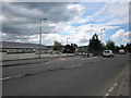
Kirkland Street
From the junction with Cassillis Road.
Image: © Billy McCrorie
Taken: 24 Apr 2012
0.03 miles
10
Cassillis Road
On Cassillis Road looking across to Kirkland Street.
Image: © Billy McCrorie
Taken: 24 Apr 2012
0.03 miles