IMAGES TAKEN NEAR TO
Lochview, CUMNOCK, KA18 4DH
Introduction
This page details the photographs taken nearby to Lochview, KA18 4DH by members of the Geograph project.
The Geograph project started in 2005 with the aim of publishing, organising and preserving representative images for every square kilometre of Great Britain, Ireland and the Isle of Man.

There are currently over 7.5m images from over14,400 individuals and you can help contribute to the project by visiting https://www.geograph.org.uk
Image Map
Images are licensed for reuse under creativecommons.org/licenses/by-sa/2.0
Notes
- Clicking on the map will re-center to the selected point.
- The higher the marker number, the further away the image location is from the centre of the postcode.
Image Listing (68 Images Found)
Images are licensed for reuse under creativecommons.org/licenses/by-sa/2.0
Image
Details
Distance
2
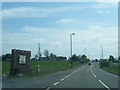
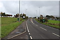
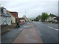
Entering New Cumnock at Pathhead
Phone mast on map can be seen on left
Image: © John Firth
Taken: 19 May 2013
0.05 miles
3
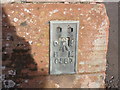
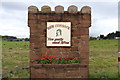
Ordnance Survey Flush Bracket G587
This can be found on the wall of a house in Pathhead, New Cumnock.
For more detail see : http://www.bench-marks.org.uk/bm329
Image: © Peter Wood
Taken: 11 Sep 2016
0.06 miles
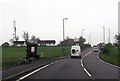
7
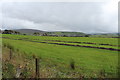
Farmland near Waterside
With view of New Cumnock in the distance.
Image: © Billy McCrorie
Taken: 19 Oct 2013
0.11 miles
8
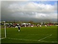
Loch Park, New Cumnock - Football ground
Loch Park, New Cumnock. Home of Glenafton Athletic FC. The part of the pitch in shot just fits into NS6114.
Image: © paul c
Taken: 25 Apr 2003
0.11 miles
10
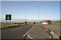
The A76 at New Cumnock
At the northwest side of New Cumnock with the Tam O' Shanter Cafe on the right closed and boarded up.
Image: © Walter Baxter
Taken: 12 Oct 2010
0.13 miles