IMAGES TAKEN NEAR TO
Muirkirk, CUMNOCK, KA18 3NJ
Introduction
This page details the photographs taken nearby to KA18 3NJ by members of the Geograph project.
The Geograph project started in 2005 with the aim of publishing, organising and preserving representative images for every square kilometre of Great Britain, Ireland and the Isle of Man.

There are currently over 7.5m images from over14,400 individuals and you can help contribute to the project by visiting https://www.geograph.org.uk
Image Map
Images are licensed for reuse under creativecommons.org/licenses/by-sa/2.0
Notes
- Clicking on the map will re-center to the selected point.
- The higher the marker number, the further away the image location is from the centre of the postcode.
Image Listing (8 Images Found)
Images are licensed for reuse under creativecommons.org/licenses/by-sa/2.0
Image
Details
Distance
1
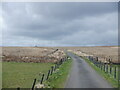
Netherwood Farm
The farm is located at a bridging point and just above the floodplain of the Greenock Water. It is a farm with an interest in both sheep and beef cattle. Located on the south facing slopes of a ridge running up to the summit of Middlefield Law (Image), there is a marked contrast between the improved grassland round the farm and the moorland vegetation of the north facing slope in the foreground. There are several areas of new plantings of trees along the small tributary valley above and to the side of the farm buildings.
Image: © Bob Forrest
Taken: 26 Feb 2007
0.02 miles
2
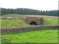
Netherwood Bridge, west of Muitkirk
The bridge carries a minor road across the Greenock Water, a tributary of the River Ayr.
Image: © G Laird
Taken: 22 Aug 2017
0.07 miles

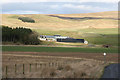
6
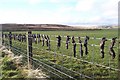
Mole Gibbet
Mole hills can cause serious damage to silage/hay making machinery hence they are controlled in many agricultural areas.
Image: © James T M Towill
Taken: 14 Jan 2006
0.13 miles
7

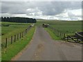
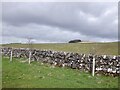
Dry-stane dyke
The valley of the Greenock Water benefits from having a band of limestone which has been quarried over the years and used to improve the quality of the grassland. Here it has been used to provide a boundary wall along the minor road which links with the A723 Strathaven to Muirkirk road in NS6930. The improved grassland lies on the slopes of a ridge which runs north-east to the summit of Middlefield Law (Image).
Image: © Bob Forrest
Taken: 26 Feb 2007
0.23 miles