IMAGES TAKEN NEAR TO
Cronberry, CUMNOCK, KA18 3LW
Introduction
This page details the photographs taken nearby to KA18 3LW by members of the Geograph project.
The Geograph project started in 2005 with the aim of publishing, organising and preserving representative images for every square kilometre of Great Britain, Ireland and the Isle of Man.

There are currently over 7.5m images from over14,400 individuals and you can help contribute to the project by visiting https://www.geograph.org.uk
Image Map (Loading...)


Getting Data...Please wait
Leaflet Map data © OpenStreetMap
Images are licensed for reuse under creativecommons.org/licenses/by-sa/2.0
Notes
- Clicking on the map will re-center to the selected point.
- The higher the marker number, the further away the image location is from the centre of the postcode.
Image Listing (18 Images Found)
Images are licensed for reuse under creativecommons.org/licenses/by-sa/2.0
Image
Details
Distance
1
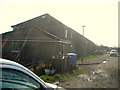
Riverside Gardens Cronberry
Residential housing on the right bank of the Bellow Water. The community has good connections to the A70 road from Cumnock to Muirkirk and onwards to Lanark and eventually to Edinburgh.
Image: © Bob Forrest
Taken: 8 Mar 2007
0.04 miles
2
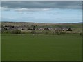
Cronberry
Cronberry seen from the track which leads to the old derelict farmhouse at Dalfad east of the A70 from Carbellow which can be seen extreme right.
Image: © John Blackwood
Taken: 8 Aug 2007
0.04 miles
3
Cronberry
Site of a mining village which once had a population of 600. Between the remaining houses and the A70 is the site of a railway junction on the Muirkirk Branch of the Glasgow and South Western Railway. The freight line down to Auchinleck closed in 1976.
Image: © Richard Webb
Taken: 5 May 2016
0.05 miles
4
Cronberry village
The main part of the village is just this row of houses, presumably built for miners. There was a double murder here recently (since I took the photo).
Image: © Kath Jones
Taken: 19 Mar 2009
0.05 miles
5
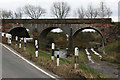
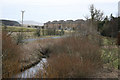
Abandoned railway bridge
The present minor road and the former mineral railway from the Gasswater mines Image required bridges to cross the Bellow Water at this point near Cronberry (NS6022). A little further east is found the remains of the dismantled branch line from Cumnock Image to Muirkirk Image and then on to Lanark.
Image: © Bob Forrest
Taken: 8 Mar 2007
0.10 miles
6
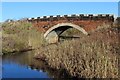
Bridge over Bellow Water near Cronberry
Image: © Leslie Barrie
Taken: 10 Nov 2013
0.11 miles
7
There it was, gone!
The viaduct, as shown in Bob Forrest's photo, has now gone to the Great Railway in the Sky!
Image: © Kath Jones
Taken: 20 May 2009
0.11 miles
9
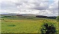
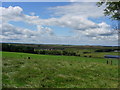
Blackside Hills, from Cronberry
View northward, across Airds Moss.
Image: © Ben Brooksbank
Taken: 21 Jun 1994
0.14 miles
10
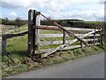
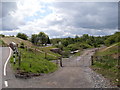
White Gate
Recent crash damage to the remaining White Gate at the old level-crossing near Cronberry.
Image: © Rab McMurdo
Taken: 18 Apr 2022
0.14 miles