IMAGES TAKEN NEAR TO
Baillie Drive, CUMNOCK, KA18 3HS
Introduction
This page details the photographs taken nearby to Baillie Drive, KA18 3HS by members of the Geograph project.
The Geograph project started in 2005 with the aim of publishing, organising and preserving representative images for every square kilometre of Great Britain, Ireland and the Isle of Man.

There are currently over 7.5m images from over14,400 individuals and you can help contribute to the project by visiting https://www.geograph.org.uk
Image Map (Loading...)


Getting Data...Please wait
Leaflet Map data © OpenStreetMap
Images are licensed for reuse under creativecommons.org/licenses/by-sa/2.0
Notes
- Clicking on the map will re-center to the selected point.
- The higher the marker number, the further away the image location is from the centre of the postcode.
Image Listing (4 Images Found)
Images are licensed for reuse under creativecommons.org/licenses/by-sa/2.0
Image
Details
Distance
1
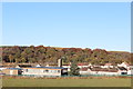
Logan Primary School
The council housing estate that the school serves dates from the mid 20th century. The homes were built in response to the need for new housing in the Cumnock area as new industrial estates opened after World War 2 and rationalisation took place in the local coal mining industry,resulting in fewer,but larger coal mines in the Cumnock and Auchinleck areas.
Image: © Bob Forrest
Taken: 20 Mar 2007
0.13 miles