IMAGES TAKEN NEAR TO
Ochiltree, CUMNOCK, KA18 2RY
Introduction
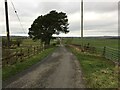
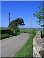
This page details the photographs taken nearby to KA18 2RY by members of the Geograph project.
The Geograph project started in 2005 with the aim of publishing, organising and preserving representative images for every square kilometre of Great Britain, Ireland and the Isle of Man.

There are currently over 7.5m images from over14,400 individuals and you can help contribute to the project by visiting https://www.geograph.org.uk
Image Map (Loading...)


Getting Data...Please wait
Leaflet Map data © OpenStreetMap
Images are licensed for reuse under creativecommons.org/licenses/by-sa/2.0
Notes
- Clicking on the map will re-center to the selected point.
- The higher the marker number, the further away the image location is from the centre of the postcode.
Image Listing (4 Images Found)
Images are licensed for reuse under creativecommons.org/licenses/by-sa/2.0
Image
Details
Distance
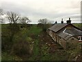
3
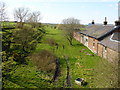
Ochiltree Railway Station
Although situated some 2Km south of the town, this station - on a narrow country road - was the nearest the line got to this centre of population, and ran from Ayr via Holehouse Junction, through Rankinston, Sinclairston through Ochiltree, Skares to Old Cumnock. The line, which was part of the Glasgow & South Western Railway was opened in 1870 and was finally closed to all traffic in 1950. The station building has been added and extended, and is a private house.
Image: © Raymond Okonski
Taken: 12 Apr 2007
0.05 miles