IMAGES TAKEN NEAR TO
Gallowlee Avenue, CUMNOCK, KA18 2PQ
Introduction
This page details the photographs taken nearby to Gallowlee Avenue, KA18 2PQ by members of the Geograph project.
The Geograph project started in 2005 with the aim of publishing, organising and preserving representative images for every square kilometre of Great Britain, Ireland and the Isle of Man.

There are currently over 7.5m images from over14,400 individuals and you can help contribute to the project by visiting https://www.geograph.org.uk
Image Map
Images are licensed for reuse under creativecommons.org/licenses/by-sa/2.0
Notes
- Clicking on the map will re-center to the selected point.
- The higher the marker number, the further away the image location is from the centre of the postcode.
Image Listing (27 Images Found)
Images are licensed for reuse under creativecommons.org/licenses/by-sa/2.0
Image
Details
Distance
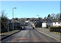
1
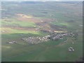
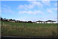
Ochiltree from the southwest
Showing the modern expansion of the village from the core at the junction of Lugar Water and Burnock Water. The farm to the left, with red-roofed barn, is Watston, and that to the right is Findlayston.
Image: © M J Richardson
Taken: 21 Apr 2013
0.05 miles
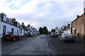
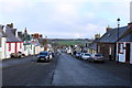
9
Looking upwards on Mill Street, Ochiltree.
Looking upwards on Mill Street from over the river.
Image: © John Steven
Taken: 22 Jun 2015
0.14 miles
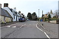
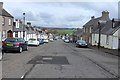
10
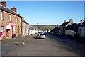
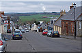
Main Street, Ochiltree, Ayrshire.
Looking north east down Main Street.
Image: © John Steven
Taken: 22 Jun 2015
0.16 miles