IMAGES TAKEN NEAR TO
Auchinleck, CUMNOCK, KA18 2NB
Introduction
This page details the photographs taken nearby to KA18 2NB by members of the Geograph project.
The Geograph project started in 2005 with the aim of publishing, organising and preserving representative images for every square kilometre of Great Britain, Ireland and the Isle of Man.

There are currently over 7.5m images from over14,400 individuals and you can help contribute to the project by visiting https://www.geograph.org.uk
Image Map
Images are licensed for reuse under creativecommons.org/licenses/by-sa/2.0
Notes
- Clicking on the map will re-center to the selected point.
- The higher the marker number, the further away the image location is from the centre of the postcode.
Image Listing (4 Images Found)
Images are licensed for reuse under creativecommons.org/licenses/by-sa/2.0
Image
Details
Distance
1
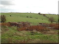
Berryhill No.2 Coal Pit
The ruins of Berryhill No.2 pithead, viewed from the bing.
Image: © Rab McMurdo
Taken: 22 Oct 2016
0.19 miles
2
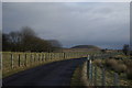
Farm road near Berryhill
A view to one of the many bings still to be found in the surrounding area
Image: © Leslie Barrie
Taken: 24 Jan 2009
0.21 miles
3
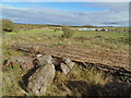
Berryhill No.3 Ironstone Pit
Lumps of concrete and long blocks of brickwork, the remains of Berryhill No.3 Ironstone Pit. The modern enclosure in the background of the photo is where the pit bing used to be. The bing was cleared and levelled years ago.
Image: © Rab McMurdo
Taken: 19 Oct 2016
0.21 miles
4
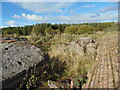
Berryhill No.3 Ironstone Pit
Lumps of concrete and long blocks of brickwork are the scant remains of the pit head at Berryhill No.3 Ironstone Pit.
Image: © Rab McMurdo
Taken: 19 Oct 2016
0.21 miles