IMAGES TAKEN NEAR TO
Dauner Way, CUMNOCK, KA18 1FP
Introduction
This page details the photographs taken nearby to Dauner Way, KA18 1FP by members of the Geograph project.
The Geograph project started in 2005 with the aim of publishing, organising and preserving representative images for every square kilometre of Great Britain, Ireland and the Isle of Man.

There are currently over 7.5m images from over14,400 individuals and you can help contribute to the project by visiting https://www.geograph.org.uk
Image Map
Images are licensed for reuse under creativecommons.org/licenses/by-sa/2.0
Notes
- Clicking on the map will re-center to the selected point.
- The higher the marker number, the further away the image location is from the centre of the postcode.
Image Listing (12 Images Found)
Images are licensed for reuse under creativecommons.org/licenses/by-sa/2.0
Image
Details
Distance
3
Knockroon
Some of the handful of completed houses here, there were supposed to be 700 by 2017.
Image: © Richard Webb
Taken: 5 May 2016
0.17 miles
4
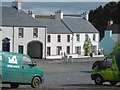
Knockroon
Supposedly a Scottish Poundbury, there are now 31 completed dwellings in what was supposed to be a 700 house development.
Image: © Richard Webb
Taken: 5 May 2016
0.17 miles
5
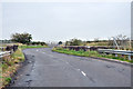
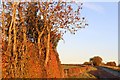
Bridge over the railway near Auchinleck
Image: © Steven Brown
Taken: 16 Sep 2012
0.20 miles
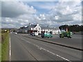
6
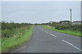
B7083 approaching Cumnock
Was once the A76 - Cumnock is now by-passed to the west by the current A76.
Image: © JThomas
Taken: 21 May 2021
0.21 miles
7
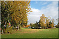
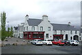
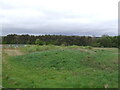
A Park in Cumnock
This recreation ground lies on the Auchinleck side of Cumnock.
Image: © Mary and Angus Hogg
Taken: 22 Oct 2015
0.22 miles
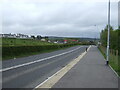
9
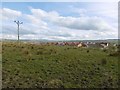
Bute Road, Holyhead
New houses seen over the hidden railway.
Image: © Richard Webb
Taken: 5 May 2016
0.23 miles