IMAGES TAKEN NEAR TO
Lintmill Road, DARVEL, KA17 0ER
Introduction
This page details the photographs taken nearby to Lintmill Road, KA17 0ER by members of the Geograph project.
The Geograph project started in 2005 with the aim of publishing, organising and preserving representative images for every square kilometre of Great Britain, Ireland and the Isle of Man.

There are currently over 7.5m images from over14,400 individuals and you can help contribute to the project by visiting https://www.geograph.org.uk
Image Map
Images are licensed for reuse under creativecommons.org/licenses/by-sa/2.0
Notes
- Clicking on the map will re-center to the selected point.
- The higher the marker number, the further away the image location is from the centre of the postcode.
Image Listing (9 Images Found)
Images are licensed for reuse under creativecommons.org/licenses/by-sa/2.0
Image
Details
Distance
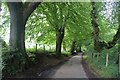
1
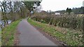
Quiet road by the River Irvine
The large white house is Waterhaughs.
Image: © Gordon Brown
Taken: 26 Mar 2024
0.06 miles
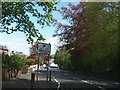
4
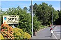
Burgh of Darvel - birth place of Sir Alexander Fleming
Sign by the A71
Image: © Leslie Barrie
Taken: 31 May 2014
0.17 miles
5
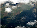
Darvel from the air
In shadow of a cloud. The east end of Newmilns can also be seen.
See also Image
Image: © Thomas Nugent
Taken: 27 Jan 2020
0.19 miles
6
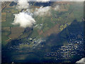
Darvel from the air
Darvel is on the right, the east end of Newmilns on the left. The dead straight Foulpapple Road can be seen running diagonally up the hill on the north side of the valley.
Image: © Thomas Nugent
Taken: 27 Jan 2020
0.19 miles
7
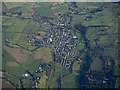
Darvel from the air
The easternmost of the Irvine Valley towns, the others being Galston and Newmilns.
Image: © Thomas Nugent
Taken: 11 Feb 2019
0.20 miles
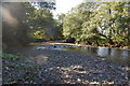
8
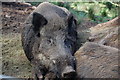
Taking a nap
Captive Boar on Lanfine Estate,which roam freely around a large fenced compound in the trees.
Image: © Scott
Taken: 15 Sep 2009
0.20 miles