IMAGES TAKEN NEAR TO
NEWMILNS, KA16 9LQ
Introduction
This page details the photographs taken nearby to KA16 9LQ by members of the Geograph project.
The Geograph project started in 2005 with the aim of publishing, organising and preserving representative images for every square kilometre of Great Britain, Ireland and the Isle of Man.

There are currently over 7.5m images from over14,400 individuals and you can help contribute to the project by visiting https://www.geograph.org.uk
Image Map
Images are licensed for reuse under creativecommons.org/licenses/by-sa/2.0
Notes
- Clicking on the map will re-center to the selected point.
- The higher the marker number, the further away the image location is from the centre of the postcode.
Image Listing (5 Images Found)
Images are licensed for reuse under creativecommons.org/licenses/by-sa/2.0
Image
Details
Distance
2
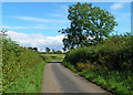
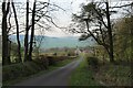
Heading for East Newton farm
The minor road leading to East Newton farm. An old limekiln lies near the tree on the right.
Image: © Mary and Angus Hogg
Taken: 19 Aug 2020
0.19 miles
3
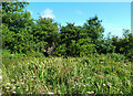
Old lime kiln near Hag Burn
An old lime kiln near Hag Burn surrounded by flowers and bushes. The 1857 OS map shows it as disused. The steep cuts around it are the remains of the old limestone quarry.
Image: © Mary and Angus Hogg
Taken: 19 Aug 2020
0.19 miles
5
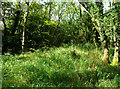
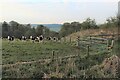
On Judge's Hill
Judge’s Hill is an ancient moot hill, a mound used in early medieval times as a meeting place to decide local matters. Local justice might also have been served here. Tricky to access through the woodland on this summer visit, the top is grassy with steep slopes leading down to Hag Burn on two sides.
Image: © Mary and Angus Hogg
Taken: 19 Aug 2020
0.25 miles