IMAGES TAKEN NEAR TO
Symington, KILMARNOCK, KA1 5PG
Introduction
This page details the photographs taken nearby to KA1 5PG by members of the Geograph project.
The Geograph project started in 2005 with the aim of publishing, organising and preserving representative images for every square kilometre of Great Britain, Ireland and the Isle of Man.

There are currently over 7.5m images from over14,400 individuals and you can help contribute to the project by visiting https://www.geograph.org.uk
Image Map
Images are licensed for reuse under creativecommons.org/licenses/by-sa/2.0
Notes
- Clicking on the map will re-center to the selected point.
- The higher the marker number, the further away the image location is from the centre of the postcode.
Image Listing (4 Images Found)
Images are licensed for reuse under creativecommons.org/licenses/by-sa/2.0
Image
Details
Distance
1
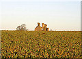
Ruin in a Field
Remains of Craigie Castle
Image: © Iain Thompson
Taken: 8 Dec 2006
0.09 miles
2
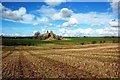
Craigie Castle Ruin
Originally the 13th century house of the Lindsay family, John Wallace of Riccarton acquired Craigie Castle through marriage in 1371 or thereabouts. The building was extended during the 15th century by adding an upper floor. The site has been unused since the 18th century.
Image: © Mary and Angus Hogg
Taken: 5 Mar 2017
0.12 miles
3
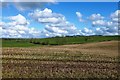
Craigie Fields
Looking over last year's arable fields at Craigie towards Laigh Langcraig, in the next square. The rolling landscape was produced by deposition of drumlins during the last Ice Age leaving sticky, stony soils.
Image: © Mary and Angus Hogg
Taken: 5 Mar 2017
0.19 miles