IMAGES TAKEN NEAR TO
Craigie Road, KILMARNOCK, KA1 5DH
Introduction
This page details the photographs taken nearby to Craigie Road, KA1 5DH by members of the Geograph project.
The Geograph project started in 2005 with the aim of publishing, organising and preserving representative images for every square kilometre of Great Britain, Ireland and the Isle of Man.

There are currently over 7.5m images from over14,400 individuals and you can help contribute to the project by visiting https://www.geograph.org.uk
Image Map
Images are licensed for reuse under creativecommons.org/licenses/by-sa/2.0
Notes
- Clicking on the map will re-center to the selected point.
- The higher the marker number, the further away the image location is from the centre of the postcode.
Image Listing (7 Images Found)
Images are licensed for reuse under creativecommons.org/licenses/by-sa/2.0
Image
Details
Distance
1
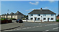
Houses in Blair Avenue, Hurlford
Part of a council housing development where many properties are now privately owned.
Image: © Mary and Angus Hogg
Taken: 13 Aug 2020
0.11 miles
2
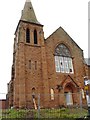
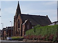
Hurlford Unionist Church
Seen just before work started to convert the building into apartments.
After being taken over by Church of Scotland this church became known as Mauchline Road Church.
Image: © Darrin Antrobus
Taken: 28 Jun 2007
0.17 miles
3
Former Unionist Church, Mauchline Road, Hurlford
Now converted for residential use.
Image: © Leslie Barrie
Taken: 31 May 2014
0.17 miles
4
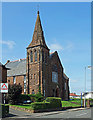
Former Mauchline Road Church
Now converted for housing, the old church was used as a hostel for the Women's Land Army during the second World War.
Image: © Mary and Angus Hogg
Taken: 13 Aug 2020
0.17 miles
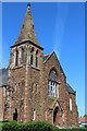
5
Derelict church
Mauchline Road Church is now boarded up
Image: © Angela Mudge
Taken: 19 Jul 2006
0.17 miles
6
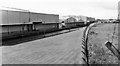
Site of Barleith Station
View westward, towards Kilmarnock; ex-GSWR Kilmarnock - Darvel line, closed when passenger service withdrawn 6/4/64; complete closure of the line was on 6/7/64. A new factory has been built on the site since.
Image: © Ben Brooksbank
Taken: 26 Sep 1974
0.22 miles
7
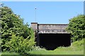
Road bridge over dismantled railway, Hurlford
Image: © Leslie Barrie
Taken: 31 May 2014
0.23 miles