IMAGES TAKEN NEAR TO
Morris Crescent, KILMARNOCK, KA1 5BH
Introduction
This page details the photographs taken nearby to Morris Crescent, KA1 5BH by members of the Geograph project.
The Geograph project started in 2005 with the aim of publishing, organising and preserving representative images for every square kilometre of Great Britain, Ireland and the Isle of Man.

There are currently over 7.5m images from over14,400 individuals and you can help contribute to the project by visiting https://www.geograph.org.uk
Image Map
Images are licensed for reuse under creativecommons.org/licenses/by-sa/2.0
Notes
- Clicking on the map will re-center to the selected point.
- The higher the marker number, the further away the image location is from the centre of the postcode.
Image Listing (12 Images Found)
Images are licensed for reuse under creativecommons.org/licenses/by-sa/2.0
Image
Details
Distance
2
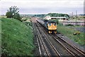
Hurlford station site 1983
Taken from Hurlford signalbox, nothing remained by 1983 to show where the station had been. The line diverging to the right served bonded warehouses and received one 80 tonne capacity rail wagon most weekdays for exports to continental Europe.
Image: © Peter Whatley
Taken: 12 Dec 1983
0.18 miles
3
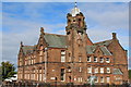
Hurlford Primary School
Category B-listed. Built 1905. Architects Andrew & Newlands.
Image: © Leslie Barrie
Taken: 5 Oct 2013
0.19 miles
4
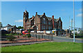
Hurlford Primary School
The building now also accommodates Hurlford Early Childhood Centre. Viewed from Academy Street.
Image: © Mary and Angus Hogg
Taken: 13 Aug 2020
0.19 miles
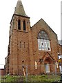
5
Former Mauchline Road Church
Now converted for housing, the old church was used as a hostel for the Women's Land Army during the second World War.
Image: © Mary and Angus Hogg
Taken: 13 Aug 2020
0.20 miles
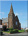
6
Hurlford Unionist Church
Seen just before work started to convert the building into apartments.
After being taken over by Church of Scotland this church became known as Mauchline Road Church.
Image: © Darrin Antrobus
Taken: 28 Jun 2007
0.20 miles
7
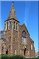
Former Unionist Church, Mauchline Road, Hurlford
Now converted for residential use.
Image: © Leslie Barrie
Taken: 31 May 2014
0.20 miles
8
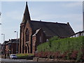
Derelict church
Mauchline Road Church is now boarded up
Image: © Angela Mudge
Taken: 19 Jul 2006
0.21 miles
9
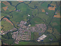
Hurlford from the air
The former Diageo Barleith distribution centre, which closed in 2010, is prominent.
Image: © Thomas Nugent
Taken: 7 Aug 2017
0.21 miles
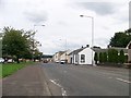
10
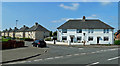
Houses in Blair Avenue, Hurlford
Part of a council housing development where many properties are now privately owned.
Image: © Mary and Angus Hogg
Taken: 13 Aug 2020
0.22 miles