IMAGES TAKEN NEAR TO
By Pass Road, BEITH, KA15 2JH
Introduction
This page details the photographs taken nearby to By Pass Road, KA15 2JH by members of the Geograph project.
The Geograph project started in 2005 with the aim of publishing, organising and preserving representative images for every square kilometre of Great Britain, Ireland and the Isle of Man.

There are currently over 7.5m images from over14,400 individuals and you can help contribute to the project by visiting https://www.geograph.org.uk
Image Map
Images are licensed for reuse under creativecommons.org/licenses/by-sa/2.0
Notes
- Clicking on the map will re-center to the selected point.
- The higher the marker number, the further away the image location is from the centre of the postcode.
Image Listing (54 Images Found)
Images are licensed for reuse under creativecommons.org/licenses/by-sa/2.0
Image
Details
Distance
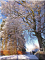
1
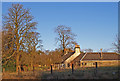
Crummock Farm, Beith
No longer a working farm.
Image: © wfmillar
Taken: 16 Dec 2010
0.03 miles
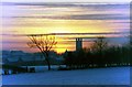
2
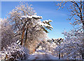
Threepwood Road, Beith
Near the junction with the A737.
Image: © wfmillar
Taken: 7 Dec 2010
0.06 miles
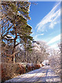
3
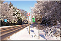
Bypass, Beith
At the junction with Threepwood Road which runs past the golf course.
Image: © wfmillar
Taken: 7 Dec 2010
0.07 miles
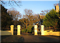
8
Hamilfield Drive, Beith
Gated driveway to the 'B' listed house.
Image: © wfmillar
Taken: 7 Dec 2010
0.11 miles
9
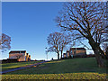
Crummock Gardens, Beith
Crummock House was demolished in 1960s and a housing estate built. Some trees and green areas saved.
Image: © wfmillar
Taken: 16 Dec 2010
0.12 miles
10
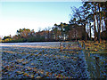
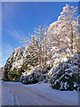
Open gate, Grangehill Estate, Beith
Cattle are allowed to graze amongst the trees on the right.
Image: © wfmillar
Taken: 14 Dec 2010
0.12 miles