IMAGES TAKEN NEAR TO
Gateside, BEITH, KA15 1HQ
Introduction
This page details the photographs taken nearby to KA15 1HQ by members of the Geograph project.
The Geograph project started in 2005 with the aim of publishing, organising and preserving representative images for every square kilometre of Great Britain, Ireland and the Isle of Man.

There are currently over 7.5m images from over14,400 individuals and you can help contribute to the project by visiting https://www.geograph.org.uk
Image Map
Images are licensed for reuse under creativecommons.org/licenses/by-sa/2.0
Notes
- Clicking on the map will re-center to the selected point.
- The higher the marker number, the further away the image location is from the centre of the postcode.
Image Listing (9 Images Found)
Images are licensed for reuse under creativecommons.org/licenses/by-sa/2.0
Image
Details
Distance
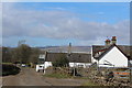
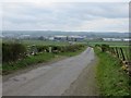
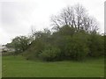
2
Broadstone Farm
Located on a single track road to the east of Beith, North Ayrshire.
Image: © Gordon Dowie
Taken: 19 Apr 2010
0.03 miles
4
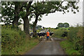
Could be a long wait...
A very large herd of dairy cattle were ambling slowly from one part of Broadstone Farm to another, blocking the local road for quite a while.
Image: © Richard Dorrell
Taken: 11 Aug 2021
0.09 miles
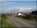
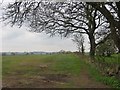
5
Broadstone
A minor road crosses a ridge south of Gateside.
Image: © Richard Webb
Taken: 25 Apr 2014
0.12 miles
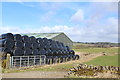
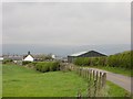
7
Minor road near Broadstone
View over an array of bonded warehouses.
Image: © Richard Webb
Taken: 25 Apr 2014
0.19 miles
8
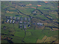
Barmill bonded warehouses from the air
The line of the former and now disused Glasgow & Kilmarnock Joint Railway Beith Branch can be seen just beyond the warehouses, with the line of the former and now disused Lanarkshire & Ayrshire Railway beyond it.
Image: © Thomas Nugent
Taken: 25 Sep 2017
0.24 miles
9
Quarry workings, Gateside
Ayrshire's complicated geology has thrown up some limestone here.
Image: © Richard Webb
Taken: 25 Apr 2014
0.25 miles