IMAGES TAKEN NEAR TO
KILWINNING, KA13 7RW
Introduction
This page details the photographs taken nearby to KA13 7RW by members of the Geograph project.
The Geograph project started in 2005 with the aim of publishing, organising and preserving representative images for every square kilometre of Great Britain, Ireland and the Isle of Man.

There are currently over 7.5m images from over14,400 individuals and you can help contribute to the project by visiting https://www.geograph.org.uk
Image Map
Images are licensed for reuse under creativecommons.org/licenses/by-sa/2.0
Notes
- Clicking on the map will re-center to the selected point.
- The higher the marker number, the further away the image location is from the centre of the postcode.
Image Listing (5 Images Found)
Images are licensed for reuse under creativecommons.org/licenses/by-sa/2.0
Image
Details
Distance
1
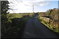
Bridge by Redwells
The road looks very lightly used.
Image: © Richard Webb
Taken: 6 Nov 2016
0.10 miles
2
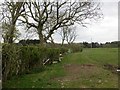
Field, Redwells
The stones suggest that this was once a road, and the maps show that the strip beside the hedge was once between two hedges.
Image: © Richard Webb
Taken: 25 Apr 2014
0.13 miles
4
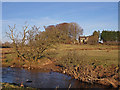
Lugton Water
The house is called Rivendell or on the Explorer map The Old School.
Image: © wfmillar
Taken: 19 Feb 2010
0.20 miles
5
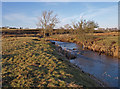
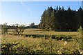
Lugton Water
Greenlea farm on the hill to the left.
Image: © wfmillar
Taken: 19 Feb 2010
0.20 miles