IMAGES TAKEN NEAR TO
Bridgend, KILWINNING, KA13 7LZ
Introduction
This page details the photographs taken nearby to Bridgend, KA13 7LZ by members of the Geograph project.
The Geograph project started in 2005 with the aim of publishing, organising and preserving representative images for every square kilometre of Great Britain, Ireland and the Isle of Man.

There are currently over 7.5m images from over14,400 individuals and you can help contribute to the project by visiting https://www.geograph.org.uk
Image Map
Images are licensed for reuse under creativecommons.org/licenses/by-sa/2.0
Notes
- Clicking on the map will re-center to the selected point.
- The higher the marker number, the further away the image location is from the centre of the postcode.
Image Listing (158 Images Found)
Images are licensed for reuse under creativecommons.org/licenses/by-sa/2.0
Image
Details
Distance
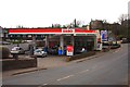
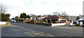
3
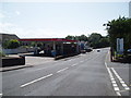
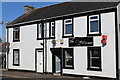
Petrol Filling Station Kilwinning
Esso filling station at Kilwinning 26th July 2009 3.00p.m.
Image: © Gordon Dowie
Taken: 26 Jul 2009
0.04 miles
5
Main Street, Kilwinning
The A737, crossing the River Garnock on the Category C Listed http://portal.historicenvironment.scot/designation/LB36239 Kilwinning Bridge.
Image: © Thomas Nugent
Taken: 6 Aug 2018
0.06 miles
8
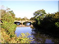
Twin Arches
A737 Road Bridge over the River Garnock at Kilwinning.
Image: © Chris Court
Taken: 13 Oct 2005
0.08 miles
9
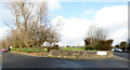
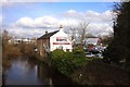
Kilwinning Cemetery
At the corner of Bridgend Lane (on the right) and the access road to Bridgend Motors Autoplex.
Image: © Thomas Nugent
Taken: 1 Mar 2019
0.08 miles
10
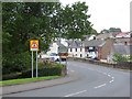
Bridgend Lane
Opposite Kilwinning Cemetery.
Image: © Thomas Nugent
Taken: 1 Mar 2019
0.08 miles