IMAGES TAKEN NEAR TO
Morville Crescent, KILWINNING, KA13 7EN
Introduction
This page details the photographs taken nearby to Morville Crescent, KA13 7EN by members of the Geograph project.
The Geograph project started in 2005 with the aim of publishing, organising and preserving representative images for every square kilometre of Great Britain, Ireland and the Isle of Man.

There are currently over 7.5m images from over14,400 individuals and you can help contribute to the project by visiting https://www.geograph.org.uk
Image Map
Images are licensed for reuse under creativecommons.org/licenses/by-sa/2.0
Notes
- Clicking on the map will re-center to the selected point.
- The higher the marker number, the further away the image location is from the centre of the postcode.
Image Listing (10 Images Found)
Images are licensed for reuse under creativecommons.org/licenses/by-sa/2.0
Image
Details
Distance
1
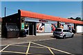
Spar - Kilwinning
General store for local housing
Image: © Ian Rainey
Taken: 25 May 2018
0.09 miles
2
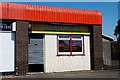
Lucky City - Kilwinning
Cantonese & European takeaway
Image: © Ian Rainey
Taken: 25 May 2018
0.09 miles
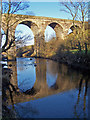
3
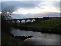
Viaduct
Old rail viaduct crossing the river Garnock. The lines of newly dug land drains at Woodgreen farm are seen on the right of the picture.
Image: © Chris Court
Taken: 4 Dec 2005
0.11 miles
4
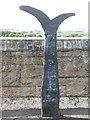
Millennium milepost
Withstanding the onslaught on the Garnock Viaduct.
Image: © Richard Webb
Taken: 13 Aug 2009
0.16 miles
5
Viaduct, Kilwinning
Crossing the River Garnock.
Image: © wfmillar
Taken: 18 Dec 2007
0.17 miles
6
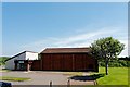
Woodwynd Community Centre - Kilwinning
http://www.aceswoodwynd.org/
Image: © Ian Rainey
Taken: 25 May 2018
0.17 miles
7

Land Drains
Newly dug land drains at the bottom of a field adjacent to the river Garnock.
Woodgreen farmhouse is on the skyline.
Image: © Chris Court
Taken: 4 Dec 2005
0.18 miles
8
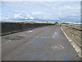
Garnock Viaduct
Deck of the viaduct, now carrying the National Cycle Route 7. As this is an obvious ned habitat, watch out for broken glass. On the left there is damage to the surface from burning a car.
The viaduct carried the Lanarkshire and Ayrshire Railway, a rival company to the Glasgow and South Western, and the line was closed to passengers in 1932 after the amalgamation of railway companies.
Image: © Richard Webb
Taken: 13 Aug 2009
0.18 miles
9
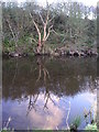
Dead Tree
Dead tree stripped of bark reflected in the River Garnock.
Image: © Chris Court
Taken: 4 Dec 2005
0.23 miles
10
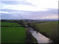
River Garnock
River Garnock photographed from the Garnock Viaduct looking north.
Image: © Chris Court
Taken: 4 Dec 2005
0.23 miles