IMAGES TAKEN NEAR TO
Lamont Drive, IRVINE, KA12 8HD
Introduction
This page details the photographs taken nearby to Lamont Drive, KA12 8HD by members of the Geograph project.
The Geograph project started in 2005 with the aim of publishing, organising and preserving representative images for every square kilometre of Great Britain, Ireland and the Isle of Man.

There are currently over 7.5m images from over14,400 individuals and you can help contribute to the project by visiting https://www.geograph.org.uk
Image Map
Images are licensed for reuse under creativecommons.org/licenses/by-sa/2.0
Notes
- Clicking on the map will re-center to the selected point.
- The higher the marker number, the further away the image location is from the centre of the postcode.
Image Listing (48 Images Found)
Images are licensed for reuse under creativecommons.org/licenses/by-sa/2.0
Image
Details
Distance
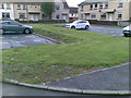
2
River Irvine, Irvine
Lamont Drive on the right. Looking up river to the industrial estate at Lamont Place..
Image: © wfmillar
Taken: 10 Mar 2009
0.07 miles
4
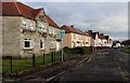
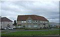
Lamont Drive, Irvine
A 'Council' estate now probably all owner occupied.
Image: © Alan Reid
Taken: 8 Feb 2017
0.08 miles
5
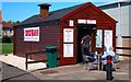
"The Chuck Wagon" burger stall
Fast food while you wait
Image: © Ian Rainey
Taken: 14 May 2018
0.09 miles
7
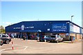
XS Stock Limited - Irvine
End of line or clearance catalogue stock, food items and cafe
Image: © Ian Rainey
Taken: 14 May 2018
0.11 miles
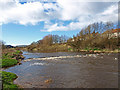
10

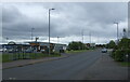
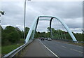
Foulartoun Arches Bridge - Irvine
Opened on 21st May 2010 it replaced the Bailey Bridge previously at this site. The old Bailey-style bridge was supposed to be in place for four years and ended up being there for 38 years. It was in a terrible state and had to be replaced as a matter of urgency. The name Foulartoun is old Saxon for Fullarton which is the area the bridge is situated. Foulartoun is understood to come from the occupation of a family who provided fowl to the King. The new bridge was officially named by primary five and six pupils from Loudoun-Montgomery Primary School
Image: © Ian Rainey
Taken: 13 Nov 2018
0.14 miles