IMAGES TAKEN NEAR TO
Racecourse Place, IRVINE, KA12 8BG
Introduction
This page details the photographs taken nearby to Racecourse Place, KA12 8BG by members of the Geograph project.
The Geograph project started in 2005 with the aim of publishing, organising and preserving representative images for every square kilometre of Great Britain, Ireland and the Isle of Man.

There are currently over 7.5m images from over14,400 individuals and you can help contribute to the project by visiting https://www.geograph.org.uk
Image Map
Images are licensed for reuse under creativecommons.org/licenses/by-sa/2.0
Notes
- Clicking on the map will re-center to the selected point.
- The higher the marker number, the further away the image location is from the centre of the postcode.
Image Listing (9 Images Found)
Images are licensed for reuse under creativecommons.org/licenses/by-sa/2.0
Image
Details
Distance
1
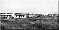
Site of Bogside (Ayrshire) Station
View SE, towards Irvine; ex-Caledonian Rly. Kilwinning - Irvine branch, which was closed 22/7/30 to passengers, 6/39 completely. (Believe me, this was the site!)
Image: © Ben Brooksbank
Taken: 26 Sep 1961
0.07 miles
2
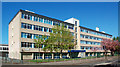
Irvine Royal Academy
This school was built as Ravenspark Academy which later merged with the original Irvine Royal Academy.
Image: © Mary and Angus Hogg
Taken: 12 May 2018
0.12 miles
3
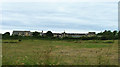
Ravenspark Hospital
Looking at the huge site of the former Ravenspark Hospital, Irvine. This geriatric hospital was originally the Cunninghame Poorshouse. It is now largely demolished to make way for housing, leaving only the central facade and the two gatehouses.
Image: © Unknown
Taken: 9 Jul 2005
0.13 miles
4
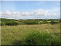
Towns Moor
Links, Irvine. The site of a racecourse, not to be confused with Bogside,the other racecourse site across the Irvine Golf Course.
Image: © Richard Webb
Taken: 13 Aug 2009
0.18 miles
5
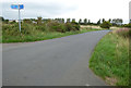
Minor road on Towns Moor
The signpost guides cyclists on the National Cycle Network Route 7.
Image: © Thomas Nugent
Taken: 6 Aug 2018
0.23 miles
6
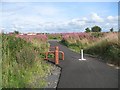
National Cycle Network route 7
The cycle path on Towns Moor. Towns moor is an area of links, and Towns sounds rather close to the Cornish Towan or Welsh Tywyn. An example of Brythonic Celtic hanging on in Strathclyde?
Image: © Richard Webb
Taken: 13 Aug 2009
0.24 miles
7
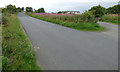
Minor road on Towns Moor
Leading to Irvine Golf Club, which can be seen in the distance.
Image: © Thomas Nugent
Taken: 6 Aug 2018
0.24 miles
8
Site of Cadgers racecourse
The Cadgers' Race Course was built by Captain John Watt at Irvine Moor. A cadger was a man who travelled on horseback delivering parcels, mail, etc..
Thanks to the Marymass web site http://www.marymass.org/raceshistory.php for the above information.
Wikipedia: https://en.wikipedia.org/wiki/Bogside_Racecourse .
The former Bogside racecourse is located nearby, on the other side of the railway line.
Image: © Thomas Nugent
Taken: 6 Aug 2018
0.24 miles
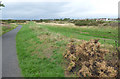
9
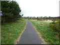
Towns Moor
Viewed from National Cycle Network Route 7.
Image: © Thomas Nugent
Taken: 6 Aug 2018
0.25 miles