IMAGES TAKEN NEAR TO
Symington Place, IRVINE, KA11 5DE
Introduction
This page details the photographs taken nearby to Symington Place, KA11 5DE by members of the Geograph project.
The Geograph project started in 2005 with the aim of publishing, organising and preserving representative images for every square kilometre of Great Britain, Ireland and the Isle of Man.

There are currently over 7.5m images from over14,400 individuals and you can help contribute to the project by visiting https://www.geograph.org.uk
Image Map
Images are licensed for reuse under creativecommons.org/licenses/by-sa/2.0
Notes
- Clicking on the map will re-center to the selected point.
- The higher the marker number, the further away the image location is from the centre of the postcode.
Image Listing (9 Images Found)
Images are licensed for reuse under creativecommons.org/licenses/by-sa/2.0
Image
Details
Distance
1
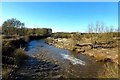
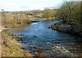
River Irvine
Looking downstream from the Long Drive bridge. The river level was significantly higher on several occasions during the 2015-16 winter.
Image: © Mary and Angus Hogg
Taken: 9 Mar 2016
0.16 miles
3
River Irvine
Looking downstream from the B7080 bridge.
Image: © wfmillar
Taken: 15 Sep 2010
0.17 miles
4
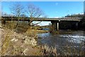
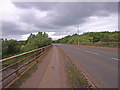
Crossing The River Irvine
This bridge takes the B7080, appropriately named Long Drive, over the River Irvine.
Image: © Mary and Angus Hogg
Taken: 9 Mar 2016
0.18 miles
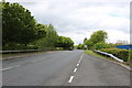
5
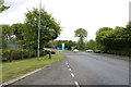
Approaching Roundabout on Long Drive, Irvine
Image: © Billy McCrorie
Taken: 7 May 2019
0.19 miles
7
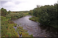
The River Irvine
An upstream view, taken in early March with water levels still falling after recent floods.
Image: © Mary and Angus Hogg
Taken: 9 Mar 2016
0.22 miles
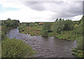
8
River Irvine
From the bridge on the B7080.
Image: © wfmillar
Taken: 15 Sep 2010
0.23 miles
9
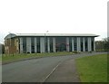
New accommodation at Riverside Business Park
Image: © Gordon Brown
Taken: 27 Feb 2006
0.24 miles