IMAGES TAKEN NEAR TO
IRVINE, KA11 4HS
Introduction
This page details the photographs taken nearby to KA11 4HS by members of the Geograph project.
The Geograph project started in 2005 with the aim of publishing, organising and preserving representative images for every square kilometre of Great Britain, Ireland and the Isle of Man.

There are currently over 7.5m images from over14,400 individuals and you can help contribute to the project by visiting https://www.geograph.org.uk
Image Map
Images are licensed for reuse under creativecommons.org/licenses/by-sa/2.0
Notes
- Clicking on the map will re-center to the selected point.
- The higher the marker number, the further away the image location is from the centre of the postcode.
Image Listing (27 Images Found)
Images are licensed for reuse under creativecommons.org/licenses/by-sa/2.0
Image
Details
Distance
2
Flooded cycle path
The water was deeper than anticipated - right up to the top of my wheels. Part of the National Cycle Network, route 73.
Image: © Richard Webb
Taken: 9 Sep 2009
0.05 miles
4
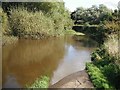
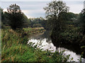
Annick Water at Irvine
Looking downstream from the bridge at Annick Road.
Image: © David Dixon
Taken: 22 Sep 2019
0.08 miles
5
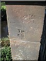
Bridge, Annick Road
Carved names in sandstone.
Image: © Richard Webb
Taken: 9 Sep 2009
0.09 miles
7
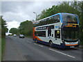
Annick Road (B7081)
Stagecoach No. 11 bus heading for Ardrossan.
Image: © JThomas
Taken: 23 May 2021
0.10 miles
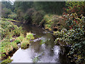
8
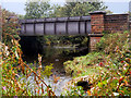
Road Bridge over Annick Water
The bridge carrying Annick Road (B7081) across Annick Water at Irvine.
Image: © David Dixon
Taken: 22 Sep 2019
0.11 miles
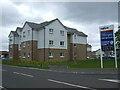
10
Menzies Irvine Hotel
Originally the Thistle Hotel
Image: © Johnny Durnan
Taken: 6 Oct 2008
0.13 miles