IMAGES TAKEN NEAR TO
Speyburn Place, IRVINE, KA11 2BQ
Introduction
This page details the photographs taken nearby to Speyburn Place, KA11 2BQ by members of the Geograph project.
The Geograph project started in 2005 with the aim of publishing, organising and preserving representative images for every square kilometre of Great Britain, Ireland and the Isle of Man.

There are currently over 7.5m images from over14,400 individuals and you can help contribute to the project by visiting https://www.geograph.org.uk
Image Map
Images are licensed for reuse under creativecommons.org/licenses/by-sa/2.0
Notes
- Clicking on the map will re-center to the selected point.
- The higher the marker number, the further away the image location is from the centre of the postcode.
Image Listing (6 Images Found)
Images are licensed for reuse under creativecommons.org/licenses/by-sa/2.0
Image
Details
Distance
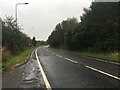
2
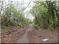
Railway trackbed, Irvine
This was a mineral line serving Perceton Colliery in the 19th century. Maps from c. 1900 show it as disused. It is now a cycle and footpath.
Image: © Richard Webb
Taken: 25 Apr 2014
0.20 miles
3
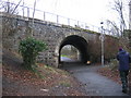
Irvine Town Trail
Part of the Irvine Town Trail follows an old railway freight line, the Doura Branch, round the eastern side of the New Town area. This line served a major iron works, several coal and ironstone pits, a saw mill and a brick works, though today evidence of these former industries is sparse. Here the alignment passes under Lochlibo Road, near Sourlie, by a skew stone arched bridge, numbered DOA 12, whose maintenance is still the responsibility of the BRB (Residuary) Ltd.
Image: © A-M-Jervis
Taken: 19 Jan 2008
0.22 miles
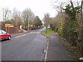
4
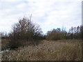
Bulrushes
Wetland area of marshy ground adjacent to the footpath on the Irvine Town Trail.
Image: © Chris Court
Taken: 18 Feb 2006
0.24 miles
6
Road Narrows
Traffic calming road narrowing on Stotfield Road Irvine. 8th April 2010 9.10am.
Image: © Gordon Dowie
Taken: 8 Apr 2010
0.25 miles