IMAGES TAKEN NEAR TO
Parkside, IRVINE, KA11 1RU
Introduction
This page details the photographs taken nearby to Parkside, KA11 1RU by members of the Geograph project.
The Geograph project started in 2005 with the aim of publishing, organising and preserving representative images for every square kilometre of Great Britain, Ireland and the Isle of Man.

There are currently over 7.5m images from over14,400 individuals and you can help contribute to the project by visiting https://www.geograph.org.uk
Image Map
Images are licensed for reuse under creativecommons.org/licenses/by-sa/2.0
Notes
- Clicking on the map will re-center to the selected point.
- The higher the marker number, the further away the image location is from the centre of the postcode.
Image Listing (5 Images Found)
Images are licensed for reuse under creativecommons.org/licenses/by-sa/2.0
Image
Details
Distance
1
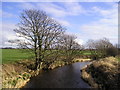
Bend in the River
Annick water, picture taken from the footbridge.
Image: © Chris Court
Taken: 18 Feb 2006
0.06 miles
2
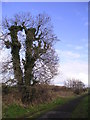
Ivy Clad Tree
Tree at the side of the Irvine New Town Trail.
Image: © Chris Court
Taken: 18 Feb 2006
0.06 miles
3
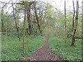
Bourtreehill
Established woodland in an Irvine park, this was once the policies of Bourtreehill, a large house demolished in the 1960s.
Image: © Richard Webb
Taken: 25 Apr 2014
0.07 miles
4
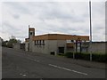
Bourtreehill Parish Church
New town architecture beside a road dedicated to buses.
Image: © Richard Webb
Taken: 25 Apr 2014
0.10 miles
5
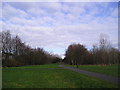
Irvine New Town Trail
The Irvine New Town Trail is a 12 mile circular walk, in part following national cycle routes, that links the town of Irvine with Kilwinning and Eglinton Country Park.
Image: © Chris Court
Taken: 18 Feb 2006
0.23 miles