IMAGES TAKEN NEAR TO
Towerlands Gate, IRVINE, KA11 1HA
Introduction
This page details the photographs taken nearby to Towerlands Gate, KA11 1HA by members of the Geograph project.
The Geograph project started in 2005 with the aim of publishing, organising and preserving representative images for every square kilometre of Great Britain, Ireland and the Isle of Man.

There are currently over 7.5m images from over14,400 individuals and you can help contribute to the project by visiting https://www.geograph.org.uk
Image Map
Images are licensed for reuse under creativecommons.org/licenses/by-sa/2.0
Notes
- Clicking on the map will re-center to the selected point.
- The higher the marker number, the further away the image location is from the centre of the postcode.
Image Listing (6 Images Found)
Images are licensed for reuse under creativecommons.org/licenses/by-sa/2.0
Image
Details
Distance
1
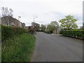
Bus road, Bourtreehill
Most towns have bus lanes, Irvine has bus roads. This was once the B730 and when Irvine expanded, it was closed and replaced by a new distributor road. This road is now open to buses only.
Image: © Richard Webb
Taken: 25 Apr 2014
0.02 miles
2
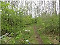
Wood, Bourtreehill
As often in urban fringe areas, lots of rubbish.
Image: © Richard Webb
Taken: 25 Apr 2014
0.05 miles
4
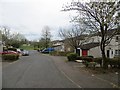
Heatherstane Way
Houses accessed by paths in Irvine.
Image: © Richard Webb
Taken: 25 Apr 2014
0.12 miles
5
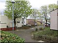
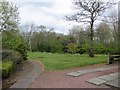
Urban Landscaping
Irvine Bourtreehill, on the route of Irvine Town Trail.
Image: © Chris Court
Taken: 18 Feb 2006
0.18 miles
6
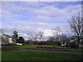
Park, Heatherstane Way
A public green space at the current edge of Irvine.
Image: © Richard Webb
Taken: 25 Apr 2014
0.24 miles