IMAGES TAKEN NEAR TO
Gigha Wynd, IRVINE, KA11 1DG
Introduction
This page details the photographs taken nearby to Gigha Wynd, KA11 1DG by members of the Geograph project.
The Geograph project started in 2005 with the aim of publishing, organising and preserving representative images for every square kilometre of Great Britain, Ireland and the Isle of Man.

There are currently over 7.5m images from over14,400 individuals and you can help contribute to the project by visiting https://www.geograph.org.uk
Image Map
Images are licensed for reuse under creativecommons.org/licenses/by-sa/2.0
Notes
- Clicking on the map will re-center to the selected point.
- The higher the marker number, the further away the image location is from the centre of the postcode.
Image Listing (21 Images Found)
Images are licensed for reuse under creativecommons.org/licenses/by-sa/2.0
Image
Details
Distance
2
Site of Dreghorn station, 1994
View SE on Station Brae, towards Crosshouse (to left): ex-G&SWR Irvine - Crosshouse line, all closed 6/4/64.
Image: © Ben Brooksbank
Taken: 21 Jun 1994
0.16 miles
4
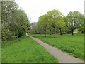
Cycle path, Irvine
Running through parkland.
Image: © Richard Webb
Taken: 25 Apr 2014
0.18 miles
5
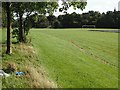
Recreation Ground
Flooded football and litter just off a foot/cyclepath in Irvine. A "tide" line can be seen, suggesting why this land was not built upon.
Image: © Richard Webb
Taken: 9 Sep 2009
0.18 miles

7
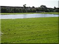
Waterlogged pitch
A recreation park beside the Annick Water. There had been a long period of heavy rain recently and quite a lot of water had yet to drain.
Image: © Richard Webb
Taken: 9 Sep 2009
0.20 miles
8
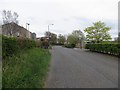
Bus road, Bourtreehill
Most towns have bus lanes, Irvine has bus roads. This was once the B730 and when Irvine expanded, it was closed and replaced by a new distributor road. This road is now open to buses only.
Image: © Richard Webb
Taken: 25 Apr 2014
0.20 miles