IMAGES TAKEN NEAR TO
Taylor Grove, TROON, KA10 7FL
Introduction
This page details the photographs taken nearby to Taylor Grove, KA10 7FL by members of the Geograph project.
The Geograph project started in 2005 with the aim of publishing, organising and preserving representative images for every square kilometre of Great Britain, Ireland and the Isle of Man.

There are currently over 7.5m images from over14,400 individuals and you can help contribute to the project by visiting https://www.geograph.org.uk
Image Map
Images are licensed for reuse under creativecommons.org/licenses/by-sa/2.0
Notes
- Clicking on the map will re-center to the selected point.
- The higher the marker number, the further away the image location is from the centre of the postcode.
Image Listing (18 Images Found)
Images are licensed for reuse under creativecommons.org/licenses/by-sa/2.0
Image
Details
Distance
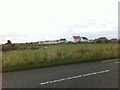
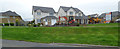
2
New Build, Barassie
Ever expanding housing.
Image: © wfmillar
Taken: 21 Sep 2010
0.11 miles
3

Barassie Farm
Farm and cottages (white building to the left of farm) all boarded up now. Soon to be overtaken by the ever expanding housing development nearby.
Image: © wfmillar
Taken: 21 Sep 2010
0.11 miles
4
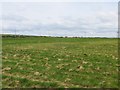
Field, Barassie
With building taking place nearby this field is unlikely to remain a field for much longer.
Image: © Richard Webb
Taken: 25 Apr 2014
0.14 miles
5
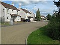
Coxswain Drive
An extensive housing estate off Deveron Road.
Image: © Jonathan Wilkins
Taken: 12 Sep 2023
0.15 miles
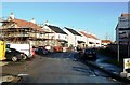
6
Housing development off Kilmarnock Road
Earls Green, by Bellway Homes https://www.bellway.co.uk/new-homes/scotland-west/earls-green .
Image: © Thomas Nugent
Taken: 6 Aug 2018
0.15 miles
7
The B746 facing NE
At the very north end of Troon the B746 leads NW inland from the shore.
Image: © Malcolm Neal
Taken: 8 May 2018
0.16 miles
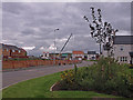
8
Marr Meadows
New building work under way at Barassie's Marr Meadows. The site is accessed via Coxwain Drive, leading off from Deveron Road.
Image: © Mary and Angus Hogg
Taken: 13 Jan 2012
0.17 miles
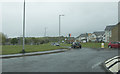
9
Kilmarnock Road
Looking towards the roundabout at Lang Road/Commonwealth Drive.
Image: © Thomas Nugent
Taken: 6 Aug 2018
0.17 miles
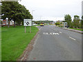
10
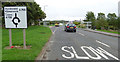
Kilmarnock Road
Sign and road marking the roundabout at Lang Road/Commonwealth Drive.
Image: © Thomas Nugent
Taken: 6 Aug 2018
0.17 miles