IMAGES TAKEN NEAR TO
Queens Drive, TROON, KA10 6SE
Introduction
This page details the photographs taken nearby to Queens Drive, KA10 6SE by members of the Geograph project.
The Geograph project started in 2005 with the aim of publishing, organising and preserving representative images for every square kilometre of Great Britain, Ireland and the Isle of Man.

There are currently over 7.5m images from over14,400 individuals and you can help contribute to the project by visiting https://www.geograph.org.uk
Image Map
Images are licensed for reuse under creativecommons.org/licenses/by-sa/2.0
Notes
- Clicking on the map will re-center to the selected point.
- The higher the marker number, the further away the image location is from the centre of the postcode.
Image Listing (64 Images Found)
Images are licensed for reuse under creativecommons.org/licenses/by-sa/2.0
Image
Details
Distance
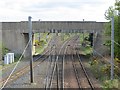
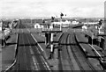
1
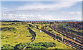
Junctions south of Barassie, 1998.
View southward from the bridge at Barassie station (behind the camera): ex-GSWR Glasgow - Ayr - Stranraer main line. The main line is curving right through its station at Troon, while straight ahead is the remnant of the former Kilmarnock & Troon Railway line to its own Troon terminus: this closed to passengers back in May 1892 when the G&SW built a new station on the Troon Loop to Lochgreen Junction. The loop remained open through Troon Goods (closed 6/7/64) until 18/4/66: as seen here in 1998, a considerable stretch of track remained in use after that, including to a depot used during the electrification of the main line in the 1980s. The hills on the horizon range from Enoch Hill (1,865 ft.), Kilmein Hill (1,406 ft.) and Keirs Hill (1,003 ft.) around Dalmellington and on the far right behind Heads of Ayr Carrick Hill (940 ft.). [What else?]
Image: © Ben Brooksbank
Taken: 27 Jun 1998
0.04 miles
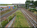
2
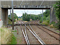
Barassie railway junction
The junction is located immediately south of Barassie station, from where this photo was taken. The line joining from the left is the Kilmarnock line, which no longer serves Barassie station. This line joins the main line to Ayr (the two tracks on the right) behind the trees. The line to the right of the '40' sign is the original line to Ayr which was bypassed in 1892 when the present 'Troon Loop' line was opened. This line closed when the main line was electrified in 1986, but the northern section is still usable.
Barassie railway works stood behind the trees in the centre of the photo.
Image: © Thomas Nugent
Taken: 6 Aug 2018
0.12 miles
3
Barassie railway junction
The junction is located immediately south of Barassie station, from where this photo was taken. The line joining from the left is the Kilmarnock line, which no longer serves Barassie station. This line joins the main line to Ayr (the two tracks on the right) behind the trees. The line to the right of the '40' sign is the original line to Ayr which was bypassed in 1892 when the present 'Troon Loop' line was opened. This line closed when the main line was electrified in 1986, but the northern section is still usable.
Barassie railway works stood behind the trees in the centre of the photo.
Image: © Thomas Nugent
Taken: 6 Aug 2018
0.12 miles
4
Site of Barassie railway works
The line in the foreground is the Troon to Kilmarnock line, near where it joins the main line to Ayr, which is out of sight to the right. The works stood in the area between this line and the distant coal train.
Viewed from Barassie station footbridge.
Image: © Thomas Nugent
Taken: 6 Aug 2018
0.12 miles
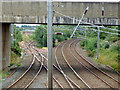
5
Barassie Junction
Here the Glasgow, Paisley, Kilmarnock and Ayr Railway crossed the Kilmarnock and Troon Railway, both becoming parts of the Glasgow and Southwestern Railway. The line from here to Kilmarnock is still open and is now single track, and the double track is the busy, electrified Ayr - Glasgow route.
View from the footbridge at Barassie Station, the bridge carries Kilmarnock Road over the railways.
Image: © Richard Webb
Taken: 25 Apr 2014
0.12 miles
6
Barassie railway junction
The Kilmarnock Line on the left and the Ayr Line on the right meet in two stages, one set of points in the foreground and a further set behind the trees in the distance. Viewed from Barassie station footbridge.
Image: © Thomas Nugent
Taken: 6 Aug 2018
0.13 miles
7
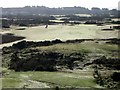
Troon Public Golf Course on a frosty day
Part of the Troon Public Golf course taken from the road bridge next to Barassie Station on a cold frosty day in February.
Image: © Ian Mockford
Taken: 18 Feb 2007
0.13 miles
8

Barassie Railway Station
Looking south towards Troon and Ayr.
Image: © Thomas Nugent
Taken: 6 Aug 2018
0.15 miles
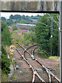
9
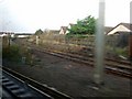
The line to Kilmarnock
Seen from a moving train passing through Barassie which has a platform on the Kilmarnock line, just visible on the left, but no services stop there. See also Image
Image: © Thomas Nugent
Taken: 25 Nov 2009
0.15 miles
10
Barassie Station
View northward, towards Glasgow and (to right) Kilmarnock; Glasgow - Ayr - Stranraer main line, junction of branch from Kilmarnock.
Image: © Ben Brooksbank
Taken: 26 Sep 1974
0.15 miles