IMAGES TAKEN NEAR TO
Station Road, MUNLOCHY, IV8 8NQ
Introduction
This page details the photographs taken nearby to Station Road, IV8 8NQ by members of the Geograph project.
The Geograph project started in 2005 with the aim of publishing, organising and preserving representative images for every square kilometre of Great Britain, Ireland and the Isle of Man.

There are currently over 7.5m images from over14,400 individuals and you can help contribute to the project by visiting https://www.geograph.org.uk
Image Map
Images are licensed for reuse under creativecommons.org/licenses/by-sa/2.0
Notes
- Clicking on the map will re-center to the selected point.
- The higher the marker number, the further away the image location is from the centre of the postcode.
Image Listing (57 Images Found)
Images are licensed for reuse under creativecommons.org/licenses/by-sa/2.0
Image
Details
Distance
1
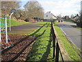
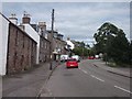
Munlochy railway station (site), Highland
Opened in 1894 on the Highland Railway's branch line from Muir of Ord to Fortrose, this station closed in 1951 to passengers and completely in 1960.
View east towards Avoch and Fortrose. The single storey building would have been end-on, just in front of the nearest house, with the single platform and line to the left of it.
Image: © Nigel Thompson
Taken: 31 Mar 2015
0.08 miles
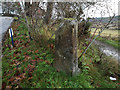
3
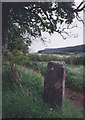
Old Milestone by the B9161, Munlochy, Knockbain parish
Old Milestone by the B9161, in parish of Knockbain (Easter Ross District), in Munlochy, near village hall, South side of road.
Inscription once read:-
: (Kessock Ferry / 5) : : (Fortrose / 5) :
A newer image of the milestone is here: Image
Surveyed
Milestone Society National ID: HI_MNIV00
Image: © Milestone Society
Taken: Unknown
0.11 miles
6
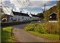
Forestry Houses - Munlochy
The Telephone Exchange is in the right of the image
Image: © valenta
Taken: 15 Oct 2019
0.11 miles
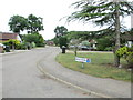
7
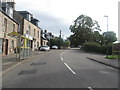
Munlochy on the Black Isle
The centre of the village.
Image: © James Denham
Taken: 2 Sep 2013
0.11 miles
8
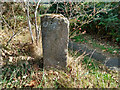
Old milestone in Munlochy
Today the stone seems to be without any inscription. The original 6 inch OS map has the information associated with the location "Kessock Ferry 5 miles, Fortrose 5 miles".
The stone lies by the junction between the main road and the direct path to the village hall (seen in the background) from the centre of the village. The stone is of similar form to the one on the approach to the village from North Kessock. Image]
The Milestone Society has also contributed an image of this stone which alerted me to its presence. Image]
Surveyed Milestone Society National ID: HI_MNIV00
Image: © Julian Paren
Taken: 12 Dec 2019
0.11 miles
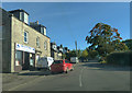
9

Millbank Road, Munlochy
Looking up Munlochy High Street, with the Bus Shelter, the Highlands headquarters of the British Trust for Conservation Volunteers, and the owners van outside Moray Firth Window Blinds.
Image: © Julian Paren
Taken: 30 Sep 2009
0.11 miles
10
Old milestone
This quadrant shaped granite milestone is on the east side of the road in Munlochy near the Village Hall. On old maps the legend is Kessock Ferry 5 on this face and Fortrose 5 on the other which would have been painted on.
Image: © Hilary Jones
Taken: 15 Sep 2022
0.11 miles