IMAGES TAKEN NEAR TO
Finlayson Court, MUIR OF ORD, IV6 7XU
Introduction
This page details the photographs taken nearby to Finlayson Court, IV6 7XU by members of the Geograph project.
The Geograph project started in 2005 with the aim of publishing, organising and preserving representative images for every square kilometre of Great Britain, Ireland and the Isle of Man.

There are currently over 7.5m images from over14,400 individuals and you can help contribute to the project by visiting https://www.geograph.org.uk
Image Map
Images are licensed for reuse under creativecommons.org/licenses/by-sa/2.0
Notes
- Clicking on the map will re-center to the selected point.
- The higher the marker number, the further away the image location is from the centre of the postcode.
Image Listing (43 Images Found)
Images are licensed for reuse under creativecommons.org/licenses/by-sa/2.0
Image
Details
Distance
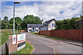
1
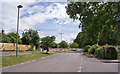
Hawthorn Road, Muir of Ord
This semi-rural residential road borders an area of woodland east of the town centre.
Image: © Richard Dorrell
Taken: 17 Jun 2014
0.05 miles
2
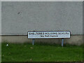
Balvaird Terrace, Muir of Ord - signage
The sign says "sheltered housing scheme - no ball games". Given that sheltered housing is intended solely for retired people, it's a tribute to the fitness of elderly Scots that such a notice is necessary.
Image: © Stephen Craven
Taken: 6 Jul 2019
0.06 miles
3
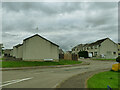
Balvaird Terrace, Muir of Ord
A sheltered housing scheme.
Image: © Stephen Craven
Taken: 6 Jul 2019
0.07 miles
4
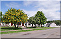
Flowering trees in Balvaird Road
Two laburnum trees are resplendent in full flower outside the sheltered housing development in Balvaid Road.
Image: © Richard Dorrell
Taken: 17 Jun 2014
0.08 miles
5
New homes for sale
A small development of new houses off Hawthorn Road stand completed, but some still await buyers.
Image: © Richard Dorrell
Taken: 17 Jun 2014
0.09 miles
6
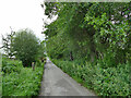
Hawthorn Road, Muir of Ord
The road serves a small number of properties east of the town.
Image: © Stephen Craven
Taken: 6 Jul 2019
0.13 miles
7
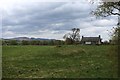
A Homestead called Strome
As seen from Balvaird Road on the north eastern edge of Muir of Ord
Image: © Chris Heaton
Taken: 11 May 2018
0.15 miles
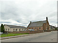
8
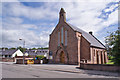
Parish Church East, Muir of Ord
Located in Seaforth Road. Once the United Free Church of Urray this became Urray East Church in 1929. It serves the united parishes of Urray and Kilchrist.
Image: © Richard Dorrell
Taken: 17 Jun 2014
0.17 miles
9
Urray East Church
According to another contributor it was formerly a Free Church Image, and a local history site confirms it became part of the Church of Scotland in 1929.
Image: © Stephen Craven
Taken: 5 Jul 2019
0.17 miles
10
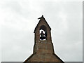
Urray East Church - bell
The church has a single bell in a turret at its west end. For context see Image
Image: © Stephen Craven
Taken: 5 Jul 2019
0.17 miles