IMAGES TAKEN NEAR TO
Muckernich Place, MUIR OF ORD, IV6 7SL
Introduction
This page details the photographs taken nearby to Muckernich Place, IV6 7SL by members of the Geograph project.
The Geograph project started in 2005 with the aim of publishing, organising and preserving representative images for every square kilometre of Great Britain, Ireland and the Isle of Man.

There are currently over 7.5m images from over14,400 individuals and you can help contribute to the project by visiting https://www.geograph.org.uk
Image Map
Images are licensed for reuse under creativecommons.org/licenses/by-sa/2.0
Notes
- Clicking on the map will re-center to the selected point.
- The higher the marker number, the further away the image location is from the centre of the postcode.
Image Listing (20 Images Found)
Images are licensed for reuse under creativecommons.org/licenses/by-sa/2.0
Image
Details
Distance
2
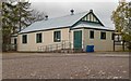
Tore Primary School
The main part of the school is an old building which houses two classrooms, ICT suite, a general purpose room/canteen, kitchen and toilet block. The staff room, office and Meeting/Resource room are now situated in the recently refurbished school house. Another class is situated in a portacabin (not visible in this picture) which is connected to the main part of the school by a corridor.
Image: © Richard Dorrell
Taken: 20 Sep 2011
0.03 miles
3
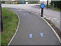
Spot the mistakes...
The pedestrian route from a 'drop off area' to the Tore primary school is marked with footprints to encourage safe use of footpaths by the children. But are the children expected to hop kangaroo style on their way to school? And do they only have left feet?
Image: © Richard Dorrell
Taken: 20 Sep 2011
0.03 miles
4
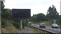
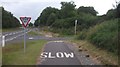
Avoid distractions whilst driving
This variable message sign had no message - no jams, no safety messages and above all no road closures! It would have had a work out a bit later when Belladrum met the orienteers and Inverness suffered some big jams.
Approaching Muir of Ord from Conon Bridge.
Image: © Richard Webb
Taken: 4 Aug 2015
0.04 miles
5
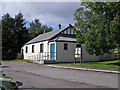
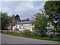
Tore village hall
The village of Tore is criss-crossed with modern major roads. This village hall, and adjacent primary school stand north of the A835 and west of the A9, and are isolated from much of the housing in Tore.
Image: © Richard Dorrell
Taken: 20 Sep 2011
0.04 miles
6
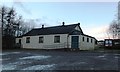
Tore Village Hall
A Highland village hall typical of its era. Erected after the stone built halls of estate beneficence and before the grant aided halls of recent years, this example, clad in corrugated iron, has been well maintained and improved in recent years.
Image: © Alpin Stewart
Taken: 11 Jan 2014
0.05 miles
7
Looking east on the A835
Here, the A835 approaches Tore roundabout. Matrix information signs, as seen here, are located on all the major routes around Inverness. The footpath on which the photographer is standing leads into a tiny triangle of minor roads on which the Tore Primary School and Village Hall are found. The village of Tore has been torn apart by the modern realignment of old roads, making pedestrian access between the various parts of the village a matter of negotiating tricky crossings of busy major roads.
Image: © Richard Dorrell
Taken: 20 Sep 2011
0.05 miles
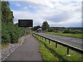
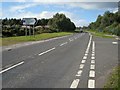
9
Cycle path, Muckernich
A cycle path accompanies the A835.
Image: © Richard Webb
Taken: 4 Aug 2015
0.08 miles
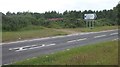
10
Road junction Gaelic lesson
Bi-lingual (Gaelic/English) road signs are common in the Highlands. The sign at this junction on the A835 just west of Tore roundabout points to A' Mhucarnaich (Muckernich), and helpfully gives the English translation for Bun-Sgoil an Todhair & Talla A' Bhaile (Tore Primary School and village hall).
Image: © Richard Dorrell
Taken: 20 Sep 2011
0.09 miles