IMAGES TAKEN NEAR TO
Cearn Romasdail, PORTREE, IV51 9TX
Introduction
This page details the photographs taken nearby to Cearn Romasdail, IV51 9TX by members of the Geograph project.
The Geograph project started in 2005 with the aim of publishing, organising and preserving representative images for every square kilometre of Great Britain, Ireland and the Isle of Man.

There are currently over 7.5m images from over14,400 individuals and you can help contribute to the project by visiting https://www.geograph.org.uk
Image Map
Images are licensed for reuse under creativecommons.org/licenses/by-sa/2.0
Notes
- Clicking on the map will re-center to the selected point.
- The higher the marker number, the further away the image location is from the centre of the postcode.
Image Listing (19 Images Found)
Images are licensed for reuse under creativecommons.org/licenses/by-sa/2.0
Image
Details
Distance
1

Path from Storr Road
At the end of Storr Road, this kissing gate is at the start of a short path which leads to a track.
Behind the trees on the left, building works are underway at the eastern end of the Kiltragleann development.
Image: © Richard Dorrell
Taken: 14 Feb 2009
0.07 miles
2
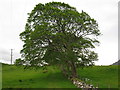
Maple and Footpath
There are two grand maple trees by the footpath here.
Image: © don cload
Taken: 24 May 2009
0.09 miles
3
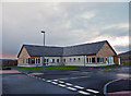
Clionaig-Fhiaclaireachd Phortr?gh - Portree Dental Clinic
The new dental clinic at Home Farm replaces the temporary set up in the bottom car park Image
The £1.2m facility, which houses three surgeries, will open for patients on 30th January 2012.
Image: © John Allan
Taken: 22 Jan 2012
0.09 miles
4
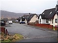
Storr Road, Portree
A residential cul-de-sac north of the town centre.
Image: © Richard Dorrell
Taken: 14 Feb 2009
0.13 miles
5
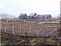
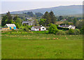
Development continues
In spite of the widely reported slump in house buying, the large Kiltragleann development on the northern side of Portree is still underway.
Here, landscape planting and footpaths are in place, and houses are under construction.
Image: © Richard Dorrell
Taken: 14 Feb 2009
0.13 miles
6
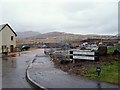
Houses by the Staffin Road
The northern outskirts of Portree.
Image: © John Allan
Taken: 20 May 2014
0.13 miles
7
Building site - Kiltragleann, Portree
There are street lights and a road name, but not a lot else.
In the present world financial situation, it is not surprising that enthusiasm to develop Portree's Kiltragleann estate has slowed somewhat.
Image: © Richard Dorrell
Taken: 12 Dec 2008
0.16 miles
8
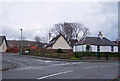
Old and modern housing, Portree
The location is the junction between Home Farm Road and Fludda Crescent.
The small white bungalow on the right is by far the oldest building in the area.
Image: © Richard Dorrell
Taken: 4 Feb 2009
0.17 miles
9
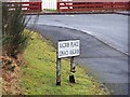
One legged road sign
The climate in the Scottish Highlands takes its toll of roadside furniture. This sign is going to be vulnerable when we get a 'Skye breeze'.
Image: © Richard Dorrell
Taken: 4 Feb 2009
0.17 miles
10
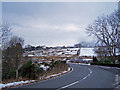
Approaching Portree
The road is the A855 which goes north from Portree to Staffin and the Trotternish Peninsula
Image: © Richard Dorrell
Taken: 9 Feb 2009
0.18 miles