IMAGES TAKEN NEAR TO
Broadford, ISLE OF SKYE, IV49 9AT
Introduction
This page details the photographs taken nearby to IV49 9AT by members of the Geograph project.
The Geograph project started in 2005 with the aim of publishing, organising and preserving representative images for every square kilometre of Great Britain, Ireland and the Isle of Man.

There are currently over 7.5m images from over14,400 individuals and you can help contribute to the project by visiting https://www.geograph.org.uk
Image Map
Images are licensed for reuse under creativecommons.org/licenses/by-sa/2.0
Notes
- Clicking on the map will re-center to the selected point.
- The higher the marker number, the further away the image location is from the centre of the postcode.
Image Listing (14 Images Found)
Images are licensed for reuse under creativecommons.org/licenses/by-sa/2.0
Image
Details
Distance
1
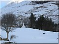
House at Kilbride
Looking very cold in the shadow of the slopes of Cnoc nam Fitheach.
Image: © John Allan
Taken: 6 Mar 2006
0.03 miles
3
Ruin, Kilbride
Ruin beside the Broadford Road.
Image: © Richard Webb
Taken: 20 Sep 2010
0.11 miles
4
Fields by Kilbride
Blaven in the distance.
Image: © Sarah Charlesworth
Taken: 25 Jun 2005
0.11 miles
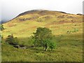
5
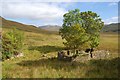
Ruins at Kilbride
The ruins of old houses give enough shelter for trees to take hold in this otherwise empty stretch of moorland.
Image: © John Allan
Taken: 10 Sep 2007
0.11 miles
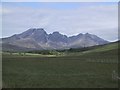
6
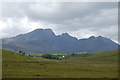
Strath : Kilbride looking towards Bl? Bheinn
Blà Bheinn (English: Blue Mountain), is a mountain on the Isle of Skye in Highland. It is usually regarded as an outlier to the Black Cuillin. It is mainly composed of gabbro, a rock with excellent grip for mountaineers and scramblers.
The normal route of ascent for walkers is from the east. A path leaves the B8083 on the shores of Loch Slapin about 4 km after the village of Na Torrin/Torrin. The path follows a burn, the Allt na Dunachie, into the corrie of Coire Uaigneich. From here a short steep route along the ridge leads to the summit. A small amount of scrambling is needed to reach the true top of the mountain.
Image: © Ken Bagnall
Taken: 17 Jun 2009
0.12 miles
7
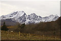
Bla Bheinn from Kilbride
Looking NNW over moorland and birch towards Bla Bheinn
Image: © Paul Taylor
Taken: 25 Mar 2008
0.12 miles
8
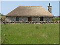
New thatched house at Kilbride
Post-June 2011, it is on the road to Elgol [B8083].
Image: © M J Richardson
Taken: 6 Jun 2016
0.13 miles
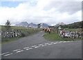
9
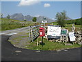
Road junction at Kilbride
The left, minor road, ends at Camas Malag. The right is the B8083 to Elgol, also a dead end, but about 16km further on.
Image: © M J Richardson
Taken: 6 Jun 2016
0.13 miles
10
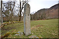
Clach na h-Annait
The stone of the mother church, an impressive 2.4m (7'9") tall standing stone in Kilbride.
It is said it was once 30' tall. Sounds pretty unlikely...
Image: © John Allan
Taken: 29 Mar 2011
0.13 miles