IMAGES TAKEN NEAR TO
Inverinate, KYLE, IV40 8HE
Introduction
This page details the photographs taken nearby to IV40 8HE by members of the Geograph project.
The Geograph project started in 2005 with the aim of publishing, organising and preserving representative images for every square kilometre of Great Britain, Ireland and the Isle of Man.

There are currently over 7.5m images from over14,400 individuals and you can help contribute to the project by visiting https://www.geograph.org.uk
Image Map
Images are licensed for reuse under creativecommons.org/licenses/by-sa/2.0
Notes
- Clicking on the map will re-center to the selected point.
- The higher the marker number, the further away the image location is from the centre of the postcode.
Image Listing (10 Images Found)
Images are licensed for reuse under creativecommons.org/licenses/by-sa/2.0
Image
Details
Distance
6
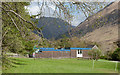
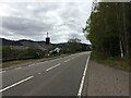
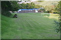
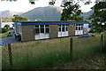
School at Inverinate
Inverinate is a small settlement alongside and below the A87 beside Loch Duich; the younger children of the village are educated here.
Image: © Trevor Littlewood
Taken: 22 May 2013
0.14 miles
8
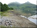
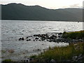
Loch Duich
Looking along the northern shore towards Shiel Bridge.
Image: © John Allan
Taken: 4 Aug 2006
0.17 miles
10
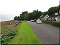
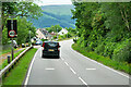
Glebe Road beside Loch Duich at Inverinate
Looking north-westward.
Image: © Peter Wood
Taken: 28 Jul 2020
0.25 miles