IMAGES TAKEN NEAR TO
Abbey Court, INVERNESS, IV3 8SN
Introduction
This page details the photographs taken nearby to Abbey Court, IV3 8SN by members of the Geograph project.
The Geograph project started in 2005 with the aim of publishing, organising and preserving representative images for every square kilometre of Great Britain, Ireland and the Isle of Man.

There are currently over 7.5m images from over14,400 individuals and you can help contribute to the project by visiting https://www.geograph.org.uk
Image Map (Loading...)


Getting Data...Please wait
Leaflet Map data © OpenStreetMap
Images are licensed for reuse under creativecommons.org/licenses/by-sa/2.0
Notes
- Clicking on the map will re-center to the selected point.
- The higher the marker number, the further away the image location is from the centre of the postcode.
Image Listing (119 Images Found)
Images are licensed for reuse under creativecommons.org/licenses/by-sa/2.0
Image
Details
Distance
2
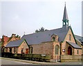
St Michael and All Angels Church
St Michael and All Angels Church at the corner of Abban Street and Lochalsh Road, Inverness, was built in 1886 on the other side of the River Ness from its present location. It was moved stone by stone with the roof being floated in sections on barges across the river in 1903/04. The interior was redesigned by Sir Ninian Comper in 1904 and 1926. A special feature is the stained glass window of the four Archangels by Comper.
Image: © Len Black
Taken: 21 Sep 2009
0.06 miles
3
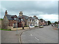
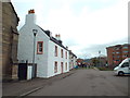
Abban Street, Inverness
Abban Street is not far from the centre of Inverness.
Image: © Malc McDonald
Taken: 22 Jun 2015
0.08 miles
4
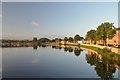
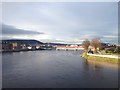
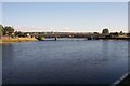
The River Ness, Inverness
View up-river along the River Ness on a clear morning in late summer. The bridge carries the A82 trunk road. The wall running along the River Bank is the Ness Flood Alleviation Scheme.
Image: © Andrew Tryon
Taken: 10 Sep 2016
0.10 miles
5
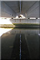
Under the bridge
A footpath connecting Huntly Street and Huntly Place runs beneath Friar's Bridge on the west bank of the River Ness. The dual carriageway bridge carries the A82. It is actually two bridges, a couple of inches apart. I was fascinated by the dancing reflection of the gap in the rippled surface of the river, which of course, the camera catches as a still image.
Image: © Richard Dorrell
Taken: 26 Aug 2013
0.11 miles
6
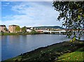
River Ness
This attractive river flows through the heart of Inverness, and is probably the town's best feature. In the distance, on the right, is Waterloo Bridge.
Image
Image: © P L Chadwick
Taken: 3 Oct 2010
0.11 miles
8
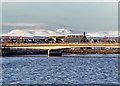
Friars' Bridge Inverness
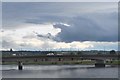
The Friar's Bridge carries the A82 trunk road to Fort William and Glasgow. Ben Wyvis in the distance dominates the skyline after a fresh fall of snow.
Image: © valenta
Taken: 17 Jan 2019
0.11 miles
9
Friar's Bridge, Inverness
The road bridge for the A82 crossing the River Ness.
Image: © Jim Barton
Taken: 8 Sep 2016
0.12 miles
10
Ness and Friars' Bridge
A view down up the Ness to the Friars' Bridge.
Image: © Andrew Wood
Taken: 27 Jul 2011
0.12 miles