IMAGES TAKEN NEAR TO
Firthview Drive, INVERNESS, IV3 8QE
Introduction
This page details the photographs taken nearby to Firthview Drive, IV3 8QE by members of the Geograph project.
The Geograph project started in 2005 with the aim of publishing, organising and preserving representative images for every square kilometre of Great Britain, Ireland and the Isle of Man.

There are currently over 7.5m images from over14,400 individuals and you can help contribute to the project by visiting https://www.geograph.org.uk
Image Map
Images are licensed for reuse under creativecommons.org/licenses/by-sa/2.0
Notes
- Clicking on the map will re-center to the selected point.
- The higher the marker number, the further away the image location is from the centre of the postcode.
Image Listing (22 Images Found)
Images are licensed for reuse under creativecommons.org/licenses/by-sa/2.0
Image
Details
Distance
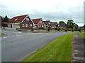
1
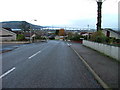
Inverness Housing Estate
Looking towards the Kessock Bridge.
Image: © Dave Fergusson
Taken: 11 Nov 2006
0.03 miles
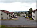
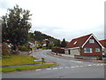
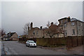
2
Scorguie Court, Inverness
Scorguie Court is a residential cul-de-sac built on a hillside in Inverness.
This view looks north east. In the background is the Kessock Bridge, which carries the trunk A9 road north from Inverness onto the Black Isle peninsula. Beyond the bridge is the Moray Firth.
Image: © Malc McDonald
Taken: 22 Jun 2015
0.09 miles
3
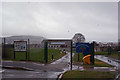
Muirtown Primary School
Viewed from a pedestrian entrance off Firthview Drive.
The school currently has about 240 pupils on roll.
Image: © Richard Dorrell
Taken: 6 Mar 2019
0.09 miles
5
Scorguie Court, Inverness
Scorguie Court is a residential cul-de-sac in Inverness.
The road running across the foreground is part of Scorguie Court, as is the short section of road heading away from the camera.
Image: © Malc McDonald
Taken: 22 Jun 2015
0.12 miles
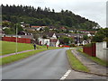
6
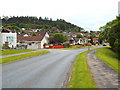
Scorguie Road, Inverness
Scorguie Road is a residential road in Inverness.
Image: © Malc McDonald
Taken: 22 Jun 2015
0.13 miles
7
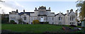
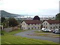
Muirtown House
Muirtown House was built for Major Hugh Robert Duff. The original part was built in 1800-1801, it later had various alterations and additions.
It is now apartments.
It is a Category B listed building.http://portal.historicenvironment.scot/designation/LB35171
Image: © Craig Wallace
Taken: 10 Nov 2017
0.14 miles
10
Muirtown House, rear view
Early 19th century mansion, Category B listed, now surrounded by modern housing estate.
Another view: Image
Image: © Richard Dorrell
Taken: 6 Mar 2019
0.14 miles