IMAGES TAKEN NEAR TO
Firthview Road, INVERNESS, IV3 8LZ
Introduction
This page details the photographs taken nearby to Firthview Road, IV3 8LZ by members of the Geograph project.
The Geograph project started in 2005 with the aim of publishing, organising and preserving representative images for every square kilometre of Great Britain, Ireland and the Isle of Man.

There are currently over 7.5m images from over14,400 individuals and you can help contribute to the project by visiting https://www.geograph.org.uk
Image Map
Images are licensed for reuse under creativecommons.org/licenses/by-sa/2.0
Notes
- Clicking on the map will re-center to the selected point.
- The higher the marker number, the further away the image location is from the centre of the postcode.
Image Listing (72 Images Found)
Images are licensed for reuse under creativecommons.org/licenses/by-sa/2.0
Image
Details
Distance
1
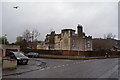
Muirtown House, rear view
Early 19th century mansion, Category B listed, now surrounded by modern housing estate.
Another view: Image
Image: © Richard Dorrell
Taken: 6 Mar 2019
0.02 miles
2
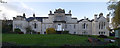
Muirtown House
This category B listed early 19th century mansion stands incongruously in the midst of a modern bungalow housing estate.
The roads are Firthview Road, with Charlston Place leading off.
Muirtown House was built by Major Hugh Robert Duff, and begun in 1800, but various alterations and additions, in different architectural styles, were made to it between then and 1851.
The house is now subdivided into eight separate private dwellings.
Rear view: Image
Firthview Road (looking the other way) Image
Image: © Richard Dorrell
Taken: 6 Mar 2019
0.03 miles
3
Muirtown House
Muirtown House was built for Major Hugh Robert Duff. The original part was built in 1800-1801, it later had various alterations and additions.
It is now apartments.
It is a Category B listed building.http://portal.historicenvironment.scot/designation/LB35171
Image: © Craig Wallace
Taken: 10 Nov 2017
0.03 miles
4
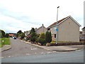
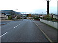
Firthview Road, Scorguie
At its junction with Charlston Place. This is just part of a housing estate of mostly bungalows.
The land here would once have been the grounds of Muirtown House, which stands just out of shot on the right of Charlston Place.
(See Image]).
Image: © Richard Dorrell
Taken: 6 Mar 2019
0.05 miles
5
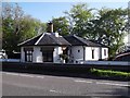
Former Toll House by the A862, Clachnaharry Road
Clachnaharry Road Toll House by the A862, in parish of Inverness (Highland District), Toll House, Clachnaharry Road.
HES Scotland Category 'B' listed.
Reference: LB35188 http://portal.historicenvironment.scot/designation/LB35188
Surveyed
Milestone Society National ID: HI.INV
Image: © Milestone Society
Taken: Unknown
0.10 miles
6
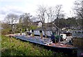
Titanic Inverness
One man has been building this model of the Titanic in his garden, next to the Caledonian Canal. It has taken him 12 years to build it, using a variety of recycled materials - including a couple of old caravans and a shed. It is 1:10 scale, about 30 metres long.
It was recently opened to the public as a museum and cafe. There are a number of other boats in the garden, including an old lifeboat and a submarine.
This is the view from the canal towpath.
Image: © Craig Wallace
Taken: 16 Apr 2012
0.10 miles
7
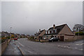
Inverness Housing Estate
Looking towards the Kessock Bridge.
Image: © Dave Fergusson
Taken: 11 Nov 2006
0.12 miles
8
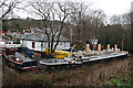
Yellow Submarine (and others)
Let's hope this lot is awaiting restoration, not further dilapidation.
Image: © Anne Burgess
Taken: 25 Dec 2015
0.12 miles
9
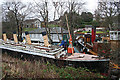
Titanic Model
This yard seems to have a curious assortment of model ships and full-size boats, all in need of some tender loving care.
See Image] for a much better description.
Image: © Anne Burgess
Taken: 25 Dec 2015
0.12 miles