IMAGES TAKEN NEAR TO
Carsegate Road South, INVERNESS, IV3 8LL
Introduction
This page details the photographs taken nearby to Carsegate Road South, IV3 8LL by members of the Geograph project.
The Geograph project started in 2005 with the aim of publishing, organising and preserving representative images for every square kilometre of Great Britain, Ireland and the Isle of Man.

There are currently over 7.5m images from over14,400 individuals and you can help contribute to the project by visiting https://www.geograph.org.uk
Image Map (Loading...)


Getting Data...Please wait
Leaflet Map data © OpenStreetMap
Images are licensed for reuse under creativecommons.org/licenses/by-sa/2.0
Notes
- Clicking on the map will re-center to the selected point.
- The higher the marker number, the further away the image location is from the centre of the postcode.
Image Listing (50 Images Found)
Images are licensed for reuse under creativecommons.org/licenses/by-sa/2.0
Image
Details
Distance
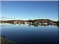
3
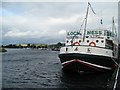
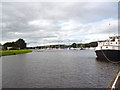
Muirtown Basin
Looking seawards towards the marina. The boat in the foreground is a floating restaurant.
Image: © Lis Burke
Taken: 22 Sep 2007
0.15 miles
4
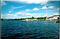
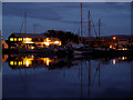
Caledonian Canal Marina
Marina in Muirtown Basin
Image: © John MacKenzie
Taken: 4 Jun 1998
0.15 miles
5
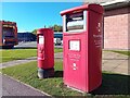
Postboxes at Inverness
IV3 116 & IV3 126P. Royal Mail list these boxes as 'Glendoe Terrace' & 'Glendoe Terrace (P)'.
Image: © David Bremner
Taken: 17 Oct 2023
0.15 miles
6
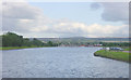
Muirtown Basin
Looking south towards Inverness across Muirtown Basin, at the eastern end of the Caledonian Canal.
Image: © Martin Clark
Taken: Unknown
0.15 miles
7
Inverness: Muirtown Basin
And canal marina. At the far end of the basin, a single lock gives access to the sea.
Image: © Dr Neil Clifton
Taken: 30 Jul 2012
0.16 miles
9
Muirtown Basin
A 200m wide section of the Caledonian Canal near its eastern end. The basin has a surface area of some 8 hectares.
Image: © John Allan
Taken: 29 Jan 2017
0.17 miles
10
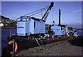
Muirtown Basin, Inverness + dredger Fairway
Dumb steam grab dredger Fairway. Used on the Caledonian Canal. Priestman crane. Now scrapped. I hope I've got the location right. It was beside the British Waterways Board Office.
Image: © Chris Allen
Taken: 13 Apr 1995
0.17 miles