IMAGES TAKEN NEAR TO
Friars Place, INVERNESS, IV3 8EY
Introduction
This page details the photographs taken nearby to Friars Place, IV3 8EY by members of the Geograph project.
The Geograph project started in 2005 with the aim of publishing, organising and preserving representative images for every square kilometre of Great Britain, Ireland and the Isle of Man.

There are currently over 7.5m images from over14,400 individuals and you can help contribute to the project by visiting https://www.geograph.org.uk
Image Map (Loading...)


Getting Data...Please wait
Leaflet Map data © OpenStreetMap
Images are licensed for reuse under creativecommons.org/licenses/by-sa/2.0
Notes
- Clicking on the map will re-center to the selected point.
- The higher the marker number, the further away the image location is from the centre of the postcode.
Image Listing (300 Images Found)
Images are licensed for reuse under creativecommons.org/licenses/by-sa/2.0
Image
Details
Distance
1
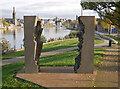
Seer, Inverness
A sculpture next to the Friars' Bridge and Friars' Shot, by the River Ness. A view through the middle towards the castle.
Image: © Craig Wallace
Taken: 20 Oct 2020
0.02 miles
2
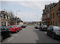
Wells Street, Inverness
A largely residential street, heading towards the River Ness. On the right is Dennis's Chinese Carry Out.
Image: © Craig Wallace
Taken: 12 Apr 2019
0.03 miles
3
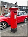
Postbox at Inverness
IV3 32. Royal Mail list this box as 'Wells Street D'.
Image: © David Bremner
Taken: 25 Jun 2023
0.03 miles
4
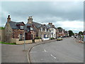
Abban Street, Inverness
Abban Street is not far from the centre of Inverness.
Image: © Malc McDonald
Taken: 22 Jun 2015
0.04 miles
5

Flood defence works
The works have temporarily caused the removal of the popular grassed seating area outside the Waterside pub.
Image: © Richard Dorrell
Taken: 27 Aug 2014
0.05 miles
6
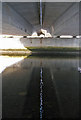
Under the bridge
A footpath connecting Huntly Street and Huntly Place runs beneath Friar's Bridge on the west bank of the River Ness. The dual carriageway bridge carries the A82. It is actually two bridges, a couple of inches apart. I was fascinated by the dancing reflection of the gap in the rippled surface of the river, which of course, the camera catches as a still image.
Image: © Richard Dorrell
Taken: 26 Aug 2013
0.05 miles
7

Friars Bridge
Friars Bridge was opened in 1987, and carries two lanes of traffic in both directions. Its name reflects the fact that there used to be a Dominican friary on the east bank of the River Ness, near where the bridge runs. The bridge carries the A82 road across the river. Although it is difficult to spot, unless you are directly underneath, the bridge is actually two identical bridges, side by side, with a very narrow gap between them.
Image: © P L Chadwick
Taken: 3 Oct 2010
0.06 miles
8
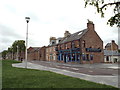
Huntly Street, Inverness
Buildings on Huntly Street in Inverness. In the foreground is The Waterfront bar. Huntly Street runs along the west bank of the River Ness.
Image: © Malc McDonald
Taken: 22 Jun 2015
0.06 miles
9
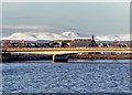
Friars' Bridge Inverness
The Friar's Bridge carries the A82 trunk road to Fort William and Glasgow. Ben Wyvis in the distance dominates the skyline after a fresh fall of snow.
Image: © valenta
Taken: 17 Jan 2019
0.06 miles
10

Friar's Bridge, Inverness
Viewed from Huntly Street on the west bank of the River Ness. The dual carriageway bridge carries the A82 over the river.
Image: © Richard Dorrell
Taken: 26 Aug 2013
0.06 miles