IMAGES TAKEN NEAR TO
Benula Road, INVERNESS, IV3 8EH
Introduction
This page details the photographs taken nearby to Benula Road, IV3 8EH by members of the Geograph project.
The Geograph project started in 2005 with the aim of publishing, organising and preserving representative images for every square kilometre of Great Britain, Ireland and the Isle of Man.

There are currently over 7.5m images from over14,400 individuals and you can help contribute to the project by visiting https://www.geograph.org.uk
Image Map
Images are licensed for reuse under creativecommons.org/licenses/by-sa/2.0
Notes
- Clicking on the map will re-center to the selected point.
- The higher the marker number, the further away the image location is from the centre of the postcode.
Image Listing (22 Images Found)
Images are licensed for reuse under creativecommons.org/licenses/by-sa/2.0
Image
Details
Distance
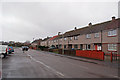
1
Kilmuir Road, Merkinch
Kilmuir Court to the right, Benula Road ahead.
Image: © Richard Dorrell
Taken: 6 Mar 2019
0.07 miles
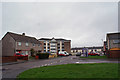
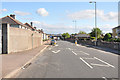
2
Kilmuir Road, Merkinch
A typical road in this residential area of Inverness.
Image: © Richard Dorrell
Taken: 6 Mar 2019
0.08 miles
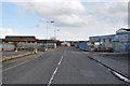
4
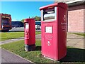
Postboxes at Inverness
IV3 116 & IV3 126P. Royal Mail list these boxes as 'Glendoe Terrace' & 'Glendoe Terrace (P)'.
Image: © David Bremner
Taken: 17 Oct 2023
0.14 miles
5
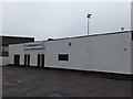
Entrance to Grant Street Park, Inverness
Grant Street Park is the home to Clachnacuddin F.C. are a semi-professional senior football club from the city of Inverness who currently play in Scotland's Highland Football League.
Image: © Alpin Stewart
Taken: 4 Apr 2014
0.18 miles
7
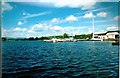
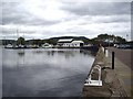
Caledonian Canal Marina
Marina in Muirtown Basin
Image: © John MacKenzie
Taken: 4 Jun 1998
0.20 miles
8
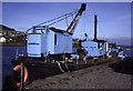
Muirtown Basin, Inverness + dredger Fairway
Dumb steam grab dredger Fairway. Used on the Caledonian Canal. Priestman crane. Now scrapped. I hope I've got the location right. It was beside the British Waterways Board Office.
Image: © Chris Allen
Taken: 13 Apr 1995
0.22 miles