IMAGES TAKEN NEAR TO
Craigton Avenue, INVERNESS, IV3 8AZ
Introduction
This page details the photographs taken nearby to Craigton Avenue, IV3 8AZ by members of the Geograph project.
The Geograph project started in 2005 with the aim of publishing, organising and preserving representative images for every square kilometre of Great Britain, Ireland and the Isle of Man.

There are currently over 7.5m images from over14,400 individuals and you can help contribute to the project by visiting https://www.geograph.org.uk
Image Map (Loading...)


Getting Data...Please wait
Leaflet Map data © OpenStreetMap
Images are licensed for reuse under creativecommons.org/licenses/by-sa/2.0
Notes
- Clicking on the map will re-center to the selected point.
- The higher the marker number, the further away the image location is from the centre of the postcode.
Image Listing (56 Images Found)
Images are licensed for reuse under creativecommons.org/licenses/by-sa/2.0
Image
Details
Distance
1
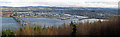
Inverness from the viewpoint on Ord Hill
There is a way marked path on Ord Hill to a good viewpoint over the Kessock Bridge and Inverness beyond. The River Ness enters the Moray Firth directly opposite the viewpoint. Hills block the southern expansion of the city and form sides to the valley occupied by Loch Ness.
This image is a stitch of three images and is available as a panorama 1050 pixels wide.
Image: © Julian Paren
Taken: 7 Mar 2015
0.05 miles
2
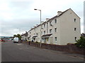
Flats on Kessock Road, Inverness
Low-rise flats on Kessock Road, in Inverness.
Image: © Malc McDonald
Taken: 22 Jun 2015
0.11 miles
3
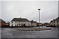
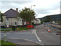
Kessock Avenue roundabout
Viewed from the end of Craigton Avenue.
I'm sure someone knows why the lamp post is not in the centre of the roundabout. Artistic licence maybe?
Image: © Richard Dorrell
Taken: 6 Mar 2019
0.11 miles
4
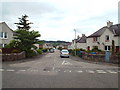
Craigton Avenue, Inverness
Craigton Avenue in South Kessock, Inverness.
Image: © Malc McDonald
Taken: 22 Jun 2015
0.11 miles
5
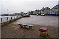
Parking area, Kessock Road
The houses here have an open view over the mouth of the River Ness.
The red square slab in the foreground is engraved with 'When the clouds are gloomy my eyes are blue'.
Image: © Richard Dorrell
Taken: 6 Mar 2019
0.11 miles
6
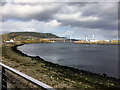
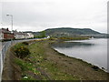
South Kessock, Mouth of River Ness
The mouth of the River Ness at South Kessock. The Kessock Bridge, carrying the A9 between Inverness and the Black Isle, can be seen in the distance.
The River Ness (Scottish Gaelic: Abhainn Nis) is a relatively short river about 12 miles long which flows from the northern end of Loch Ness, through Loch Dochfour, to Inverness, where it discharges into the Beauly Firth. The river is the origin of the name of the city of Inverness which is from the Scottish Gaelic: Inbhir Nis, meaning "Mouth of the Ness".
Image: © David Dixon
Taken: 4 Apr 2017
0.12 miles
7
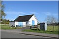
Sewage pumping station, South Kessock
Image: © Bill Harrison
Taken: 12 Apr 2024
0.12 miles
8
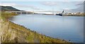
Mouth of the River Ness
Here the River Ness flows out towards the Beauly Firth and the Kessock Bridge.
Carnarc Point is on the left, with Ord Hill beyond it. A cargo ship is unloading at Inverness Harbour on the right, see Image]
Image: © Craig Wallace
Taken: 5 Nov 2012
0.13 miles
9
Kessock Road, Inverness
To the right of the image, work is in progress on the River Ness flood defence scheme.
Image: © Malc McDonald
Taken: 22 Jun 2015
0.13 miles
10
River Ness riverbank
The lighthouse at Carnac Point can be seen in the distance at the mouth of the river.
Image: © don cload
Taken: 4 May 2010
0.14 miles