IMAGES TAKEN NEAR TO
Old School Place, INVERNESS, IV3 8AP
Introduction
This page details the photographs taken nearby to Old School Place, IV3 8AP by members of the Geograph project.
The Geograph project started in 2005 with the aim of publishing, organising and preserving representative images for every square kilometre of Great Britain, Ireland and the Isle of Man.

There are currently over 7.5m images from over14,400 individuals and you can help contribute to the project by visiting https://www.geograph.org.uk
Image Map (Loading...)


Getting Data...Please wait
Leaflet Map data © OpenStreetMap
Images are licensed for reuse under creativecommons.org/licenses/by-sa/2.0
Notes
- Clicking on the map will re-center to the selected point.
- The higher the marker number, the further away the image location is from the centre of the postcode.
Image Listing (29 Images Found)
Images are licensed for reuse under creativecommons.org/licenses/by-sa/2.0
Image
Details
Distance
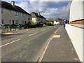
1
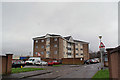
Flats in Coronation Park
Not the most desirable of addresses in Inverness - but some of the flats on the upper floors have a spectacular open view over the mouth of the River Ness.
Image: © Richard Dorrell
Taken: 6 Mar 2019
0.09 miles
2
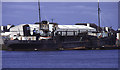
SS Robert Weir, Inverness
This steam suction dredger was built for Preston Harbour Board and later used on the east coast of Scotland until about 1990. It has now been scrapped, at Millom, but its main engine was for sale at Preston Steam Services near Canterbury.
Image: © Chris Allen
Taken: 13 Apr 1995
0.11 miles
3
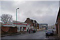
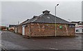
Spar shop, Thornbush Road
Located close to the South Kessock housing estate.
Image: © Richard Dorrell
Taken: 6 Mar 2019
0.11 miles
4
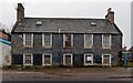
Thornbush House
Situated adjacent to the former Thornbush Brewery, incredibly Thornbush House is neither listed or on the Buildings at Risk Register for Scotland.
Early pictures show that the building once supported a pair of fine dormer windows, that have at some stage been replaced by modern Velux type roof lights. The history of the building is unclear but thought to date from the early 19th century.
Image: © valenta
Taken: 25 Dec 2017
0.12 miles
6
Thornbush Road Warehouses
Former warehouse by the Thornbush Quay
Image: © valenta
Taken: 25 Dec 2017
0.12 miles
7
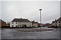
Kessock Avenue roundabout
Viewed from the end of Craigton Avenue.
I'm sure someone knows why the lamp post is not in the centre of the roundabout. Artistic licence maybe?
Image: © Richard Dorrell
Taken: 6 Mar 2019
0.13 miles
8
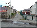
Path off Kessock Road, Inverness
A footpath leading away from Kessock Road in Inverness.
Image: © Malc McDonald
Taken: 22 Jun 2015
0.13 miles
10
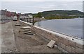
Flood defence works, by Kessock Road
A concrete wall is being constructed alongside the road. One lane of the road is closed, the other lane is controlled with traffic lights.
Here the River Ness curves round past Carnarc Point, as it joins the Beauly Firth. The Kessock Bridge is visible in the distance on the right.
Image: © Craig Wallace
Taken: 15 May 2015
0.15 miles