IMAGES TAKEN NEAR TO
FORRES, IV36 3TN
Introduction
This page details the photographs taken nearby to IV36 3TN by members of the Geograph project.
The Geograph project started in 2005 with the aim of publishing, organising and preserving representative images for every square kilometre of Great Britain, Ireland and the Isle of Man.

There are currently over 7.5m images from over14,400 individuals and you can help contribute to the project by visiting https://www.geograph.org.uk
Image Map
Images are licensed for reuse under creativecommons.org/licenses/by-sa/2.0
Notes
- Clicking on the map will re-center to the selected point.
- The higher the marker number, the further away the image location is from the centre of the postcode.
Image Listing (8 Images Found)
Images are licensed for reuse under creativecommons.org/licenses/by-sa/2.0
Image
Details
Distance
1
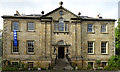
Invererne House
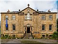
The house was originally named Tannachy, and it was built in 1818 for General William Grant by an unknown architect. The pillared central bay is unusual, with three urns on the roofline, an oculus below, and a Venetian window echoed by the door. The house was open for the Doors Open Day in 2018, as the blue banner proclaims. It is not normally open to the public.
Image: © Anne Burgess
Taken: 22 Sep 2018
0.01 miles
2
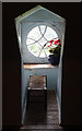
Inside the Oculus
Image: © Anne Burgess
Taken: 22 Sep 2018
0.01 miles
3
Invererne House Detail
Looking up at the oculus window on Invererne House, an interior view from the Oculus here, by Anne Burgess Image]
Image: © valenta
Taken: 22 Sep 2018
0.01 miles
4
Invererne House Detail
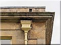
Although Invererne House dates from 1818 this close view of the downpipe hopper head has the date 1888 cast on it
Image: © valenta
Taken: 22 Sep 2018
0.01 miles
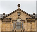
5
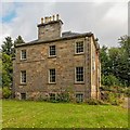
Invererne House
The Category A listed Invererne House dates from 1818. Visited during the Doors Open Days 2018 Close view of the centre oculus window here Image]
Image: © valenta
Taken: 22 Sep 2018
0.02 miles
6
Invererne House
The Category A listed Invererne House dates from 1818, although in this corner view of the house is of note, in that the downpipe hopper head has the date 1888 cast on it. Image]
Visited during the Doors Open Days 2018
Image: © valenta
Taken: 22 Sep 2018
0.02 miles
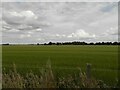
7
Invererne
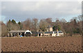
The farm and buildings, sheltered from the north by a clump of mature trees, stands in the middle of the flat flood plain north of Forres. Its name used to be Tannachy, but it was altered to Invererne some time before 1834. Invererne House itself, a category A listed building, is hidden by the trees. The steading, seen here, dates from 1818 and is category B listed. Pity about the modern dutch barn to the left.
Image: © Anne Burgess
Taken: 11 Mar 2011
0.11 miles