IMAGES TAKEN NEAR TO
FORRES, IV36 2SN
Introduction
This page details the photographs taken nearby to IV36 2SN by members of the Geograph project.
The Geograph project started in 2005 with the aim of publishing, organising and preserving representative images for every square kilometre of Great Britain, Ireland and the Isle of Man.

There are currently over 7.5m images from over14,400 individuals and you can help contribute to the project by visiting https://www.geograph.org.uk
Image Map (Loading...)


Getting Data...Please wait
Leaflet Map data © OpenStreetMap
Images are licensed for reuse under creativecommons.org/licenses/by-sa/2.0
Notes
- Clicking on the map will re-center to the selected point.
- The higher the marker number, the further away the image location is from the centre of the postcode.
Image Listing (18 Images Found)
Images are licensed for reuse under creativecommons.org/licenses/by-sa/2.0
Image
Details
Distance
1
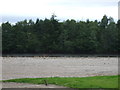
Flood defences, Forres
The Findhorn, draining a vast area of the Monadh Liath has a fearsome reputation for destructive flooding. A bank above the braided riverbed protects the land to the north.
Image: © Richard Webb
Taken: 14 Aug 2018
0.12 miles
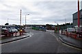
2
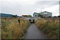
Greshop Industrial Estate, Forres
A tarred path passes under the railway into the industrial estate, it is a waymarked route from Broom of Moy and the bridge over the Findhorn.
Image: © Richard Webb
Taken: 14 Aug 2018
0.15 miles
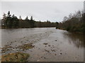
3
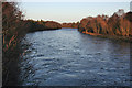
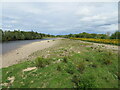
River Findhorn
Though not in spate, the river level looks fairly high.
Image: © Anne Burgess
Taken: 25 Feb 2011
0.17 miles
4
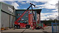
AJ Engineering's New Lifting Equipment
AJ Engineering displaying some of their lifting plant in their yard.
Image: © Graham Alexander
Taken: 27 Apr 2018
0.18 miles
5
River Findhorn near Broom of Moy
Looking upstream at Gordon's Pool with 2.1m on the gauge. The highest recorded at the gauge was 4.723m on 17 August 1970. At that height you wouldn't get anywhere near this location.
Image: © Alan hodgson
Taken: 22 Mar 2011
0.18 miles
6
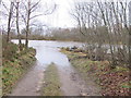
River Findhorn near Broom of Moy
Flooded access track leading to Gordon's Pool. The gauge was reading 2.1m at the time.
Image: © Alan hodgson
Taken: 22 Mar 2011
0.18 miles
7
Greshop Industrial Estate, Forres
West Road.
Image: © Richard Webb
Taken: 14 Aug 2018
0.19 miles
8
The River Finhorn
From National Cycle Route 1.
Image: © JThomas
Taken: 19 Jul 2014
0.19 miles
9
River Findhorn
Looking north-eastward from the Broom of Moy footbridge.
Image: © Peter Wood
Taken: 12 May 2022
0.19 miles