IMAGES TAKEN NEAR TO
Walker Court, FORRES, IV36 1ZQ
Introduction
This page details the photographs taken nearby to Walker Court, IV36 1ZQ by members of the Geograph project.
The Geograph project started in 2005 with the aim of publishing, organising and preserving representative images for every square kilometre of Great Britain, Ireland and the Isle of Man.

There are currently over 7.5m images from over14,400 individuals and you can help contribute to the project by visiting https://www.geograph.org.uk
Image Map
Images are licensed for reuse under creativecommons.org/licenses/by-sa/2.0
Notes
- Clicking on the map will re-center to the selected point.
- The higher the marker number, the further away the image location is from the centre of the postcode.
Image Listing (167 Images Found)
Images are licensed for reuse under creativecommons.org/licenses/by-sa/2.0
Image
Details
Distance
2
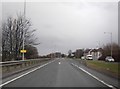
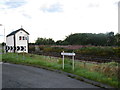
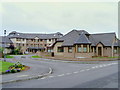
A96 Forres near entrance to train station
Image: © thejackrustles
Taken: 26 Dec 2022
0.02 miles
5
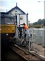
Exchanging tokens at Forres East Signalbox
Manual exchange of tokens is becoming an increasingly rare sight on the railways of Britain (apart from the 'heritage' lines). A token is required to allow trains to proceed safely along single line sections of track but these days they tend to be electronic, usually controlled from signalling centres many miles away. The signalbox at Forres, the only survivor of three that were once in the area, controls the single line sections to Nairn and to Elgin.
Image: © John Lucas
Taken: 3 Oct 2007
0.05 miles
6
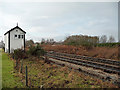
Forres East signal box
More than 100 years old and still active.
Image: © John Allan
Taken: 24 Jan 2010
0.05 miles
8
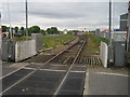
Forres 1st railway station (site), Moray, 2017
Opened in 1858 by the Inverness & Aberdeen Junction Railway, later part of the Highland Railway, on the line from Inverness to Keith, this station closed in 1863 when it was replaced by the second station, located on the lines curving left.
View west towards Brodie and Inverness. The original station was on the line that would have continued straight ahead, to the right of the signal box, where the piles of builders' materials can be seen. This 1858 straight line reopened in October 2017 with a new, third station, in the distance. The second station, along with the tracks curving left in this image, was removed.
Image: © Nigel Thompson
Taken: 24 May 2017
0.06 miles
10
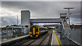
Inverness bound DMU at the new, but hideously functional, station at Forres
Image: © Peter Moore
Taken: 26 Oct 2017
0.08 miles