IMAGES TAKEN NEAR TO
Bynack Place, FORRES, IV36 1GA
Introduction
This page details the photographs taken nearby to Bynack Place, IV36 1GA by members of the Geograph project.
The Geograph project started in 2005 with the aim of publishing, organising and preserving representative images for every square kilometre of Great Britain, Ireland and the Isle of Man.

There are currently over 7.5m images from over14,400 individuals and you can help contribute to the project by visiting https://www.geograph.org.uk
Image Map
Images are licensed for reuse under creativecommons.org/licenses/by-sa/2.0
Notes
- Clicking on the map will re-center to the selected point.
- The higher the marker number, the further away the image location is from the centre of the postcode.
Image Listing (8 Images Found)
Images are licensed for reuse under creativecommons.org/licenses/by-sa/2.0
Image
Details
Distance
1
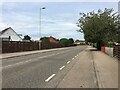
Traffic Lights on Grantown Road
Traffic lights controlling the junction of Grantown Road with Mannachie Road in Forres.
Image: © David Dixon
Taken: 5 Apr 2017
0.15 miles
3
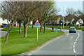
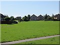
Mannachie Gardens
These are the backs of the houses along Mannachie Gardens, one of the new housing estates that have sprung up on the outskirts of Forres.
Image: © Anne Burgess
Taken: 31 Aug 2016
0.17 miles
4
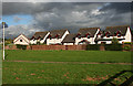
New Housing in Forres
These are the backs of houses in an estate off Mannachie Road.
Image: © Anne Burgess
Taken: 31 Aug 2016
0.19 miles
5
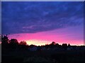
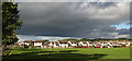
Amazing sunset in Forres
Wonderful colours
Image: © thejackrustles
Taken: 21 May 2010
0.19 miles
6
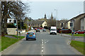
New houses, Grantown Road
Forres is expanding southwards and there are some newish houses here.
Image: © Richard Webb
Taken: 5 Aug 2014
0.20 miles
8
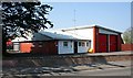
Forres Fire Station
It seems to be operated by part-time firefighters as there was no sign of anyone there this morning.
Image: © Anne Burgess
Taken: 8 May 2008
0.25 miles